You are here: Home > Network List > OH - Ohio Seismic Network Stations List
> Station MWLO Mercer Wildlife Area Ohio > Earthquake Result Viewer
MWLO Mercer Wildlife Area Ohio - Earthquake Result Viewer
| Earthquake location: |
Ionian Sea |
| Earthquake latitude/longitude: |
37.5/20.6 |
| Earthquake time(UTC): |
2018/10/25 (298) 22:54:52 GMT |
| Earthquake Depth: |
14 km |
| Earthquake Magnitude: |
6.8 Mww |
| Earthquake Catalog/Contributor: |
NEIC PDE/us |
|
| Network: |
OH Ohio Seismic Network |
| Station: |
MWLO Mercer Wildlife Area Ohio |
| Lat/Lon: |
40.50 N/84.57 W |
| Elevation: |
266 m |
|
| Distance: |
76.5 deg |
| Az: |
310.79 deg |
| Baz: |
52.141 deg |
| Ray Param: |
0.050968323 |
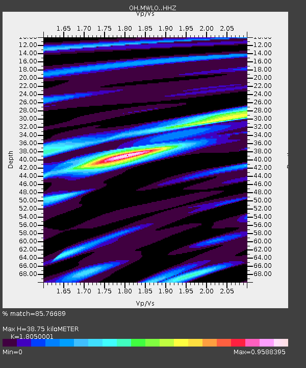
| Estimated Moho Depth: |
38.75 km |
| Estimated Crust Vp/Vs: |
1.81 |
| Assumed Crust Vp: |
6.498 km/s |
| Estimated Crust Vs: |
3.6 km/s |
| Estimated Crust Poisson's Ratio: |
0.28 |
|
| Radial Match: |
85.76689 % |
| Radial Bump: |
344 |
| Transverse Match: |
63.13632 % |
| Transverse Bump: |
400 |
| SOD ConfigId: |
13570011 |
| Insert Time: |
2019-05-01 14:55:01.485 +0000 |
| GWidth: |
2.5 |
| Max Bumps: |
400 |
| Tol: |
0.001 |
|

Signal To Noise
| Channel | StoN | STA | LTA |
| OH:MWLO: :HHZ:20181025T23:06:10.439976Z | 2.5148337 | 6.620344E-7 | 2.6325174E-7 |
| OH:MWLO: :HHN:20181025T23:06:10.439976Z | 0.54448724 | 1.903209E-7 | 3.4954152E-7 |
| OH:MWLO: :HHE:20181025T23:06:10.439976Z | 0.8095511 | 1.6963601E-7 | 2.095433E-7 |
| Arrivals |
| Ps | 5.0 SECOND |
| PpPs | 16 SECOND |
| PsPs/PpSs | 21 SECOND |


