You are here: Home > Network List > TS - TERRAscope (Southern California Seismic Network) Stations List
> Station BAR Barrett Dam, California, USA > Earthquake Result Viewer
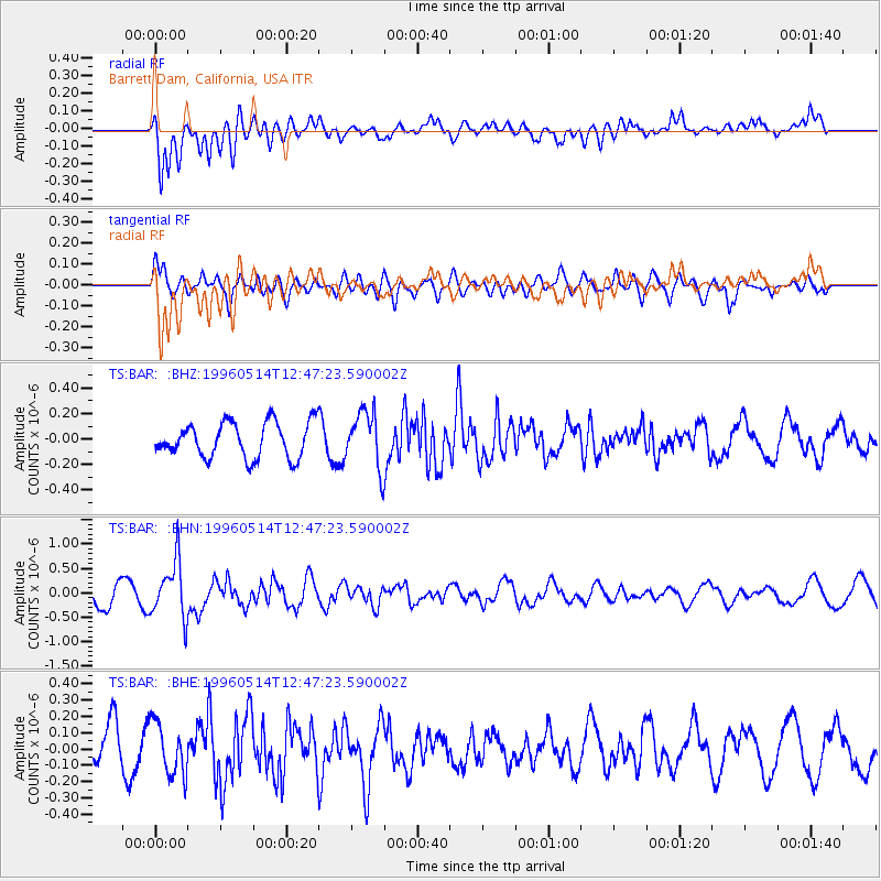
BAR Barrett Dam, California, USA - Earthquake Result Viewer
*The percent match for this event was below the threshold and hence no stack was calculated.
| Earthquake location: |
Fiji Islands Region |
| Earthquake latitude/longitude: |
-18.0/-178.5 |
| Earthquake time(UTC): |
1996/05/14 (135) 12:36:59 GMT |
| Earthquake Depth: |
605 km |
| Earthquake Magnitude: |
5.5 MB, 5.6 UNKNOWN |
| Earthquake Catalog/Contributor: |
WHDF/NEIC |
|
| Network: |
TS TERRAscope (Southern California Seismic Network) |
| Station: |
BAR Barrett Dam, California, USA |
| Lat/Lon: |
32.68 N/116.67 W |
| Elevation: |
548 m |
|
| Distance: |
77.7 deg |
| Az: |
49.584 deg |
| Baz: |
239.245 deg |
| Ray Param: |
$rayparam |
*The percent match for this event was below the threshold and hence was not used in the summary stack. |
|
| Radial Match: |
78.46145 % |
| Radial Bump: |
400 |
| Transverse Match: |
69.50061 % |
| Transverse Bump: |
400 |
| SOD ConfigId: |
4480 |
| Insert Time: |
2010-02-26 13:59:28.680 +0000 |
| GWidth: |
2.5 |
| Max Bumps: |
400 |
| Tol: |
0.001 |
|
Signal To Noise
| Channel | StoN | STA | LTA |
| TS:BAR: :BHN:19960514T12:47:23.590002Z | 2.8798418 | 5.756263E-7 | 1.9988123E-7 |
| TS:BAR: :BHE:19960514T12:47:23.590002Z | 1.5763531 | 1.6143004E-7 | 1.02407284E-7 |
| TS:BAR: :BHZ:19960514T12:47:23.590002Z | 1.596226 | 2.2129993E-7 | 1.3863946E-7 |
| Arrivals |
| Ps | |
| PpPs | |
| PsPs/PpSs | |


