You are here: Home > Network List > TA - USArray Transportable Network (new EarthScope stations) Stations List
> Station A22K Sinclair Lake, AK, USA > Earthquake Result Viewer
A22K Sinclair Lake, AK, USA - Earthquake Result Viewer
*The percent match for this event was below the threshold and hence no stack was calculated.
| Earthquake location: |
Ionian Sea |
| Earthquake latitude/longitude: |
37.5/20.6 |
| Earthquake time(UTC): |
2018/10/25 (298) 22:54:52 GMT |
| Earthquake Depth: |
14 km |
| Earthquake Magnitude: |
6.8 Mww |
| Earthquake Catalog/Contributor: |
NEIC PDE/us |
|
| Network: |
TA USArray Transportable Network (new EarthScope stations) |
| Station: |
A22K Sinclair Lake, AK, USA |
| Lat/Lon: |
71.00 N/154.97 W |
| Elevation: |
6.0 m |
|
| Distance: |
71.7 deg |
| Az: |
358.463 deg |
| Baz: |
3.735 deg |
| Ray Param: |
$rayparam |
*The percent match for this event was below the threshold and hence was not used in the summary stack. |
|
| Radial Match: |
89.075806 % |
| Radial Bump: |
367 |
| Transverse Match: |
71.173874 % |
| Transverse Bump: |
400 |
| SOD ConfigId: |
13570011 |
| Insert Time: |
2019-05-01 14:56:19.322 +0000 |
| GWidth: |
2.5 |
| Max Bumps: |
400 |
| Tol: |
0.001 |
|
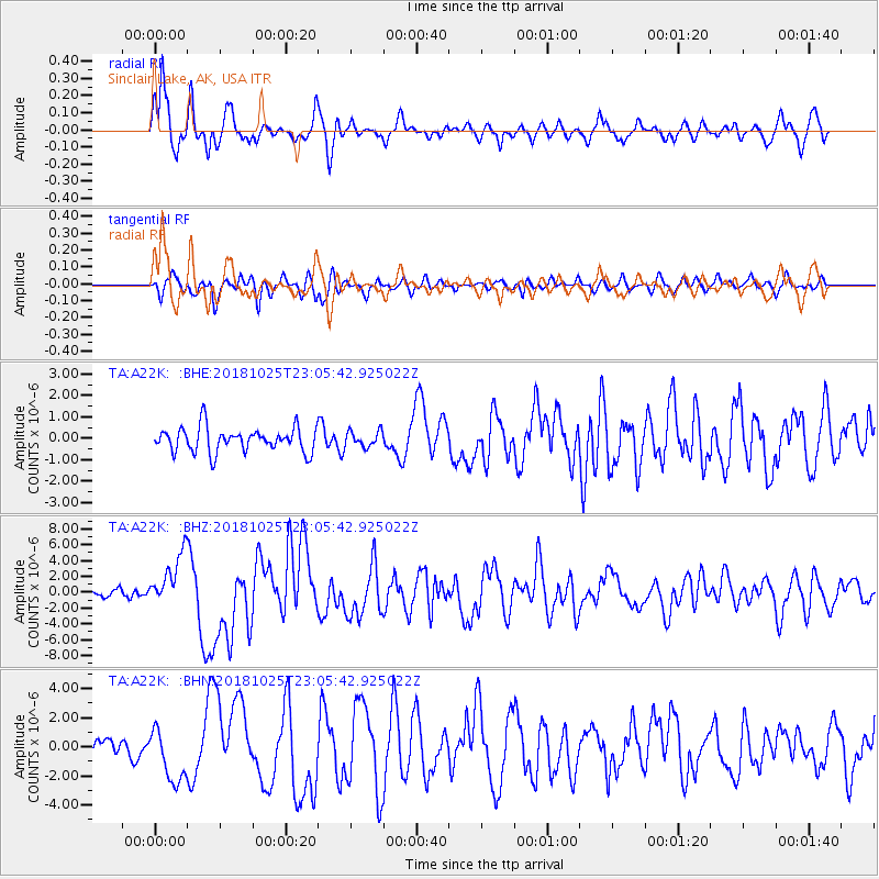
Signal To Noise
| Channel | StoN | STA | LTA |
| TA:A22K: :BHZ:20181025T23:05:42.925022Z | 5.91554 | 3.3241686E-6 | 5.619383E-7 |
| TA:A22K: :BHN:20181025T23:05:42.925022Z | 3.254335 | 1.8401009E-6 | 5.654307E-7 |
| TA:A22K: :BHE:20181025T23:05:42.925022Z | 0.65086764 | 3.6736918E-7 | 5.644299E-7 |
| Arrivals |
| Ps | |
| PpPs | |
| PsPs/PpSs | |


