You are here: Home > Network List > TA - USArray Transportable Network (new EarthScope stations) Stations List
> Station D20K Etivluk River, AK, USA > Earthquake Result Viewer
D20K Etivluk River, AK, USA - Earthquake Result Viewer
| Earthquake location: |
Ionian Sea |
| Earthquake latitude/longitude: |
37.5/20.6 |
| Earthquake time(UTC): |
2018/10/25 (298) 22:54:52 GMT |
| Earthquake Depth: |
14 km |
| Earthquake Magnitude: |
6.8 Mww |
| Earthquake Catalog/Contributor: |
NEIC PDE/us |
|
| Network: |
TA USArray Transportable Network (new EarthScope stations) |
| Station: |
D20K Etivluk River, AK, USA |
| Lat/Lon: |
68.71 N/156.61 W |
| Elevation: |
577 m |
|
| Distance: |
74.1 deg |
| Az: |
358.928 deg |
| Baz: |
2.334 deg |
| Ray Param: |
0.052575 |
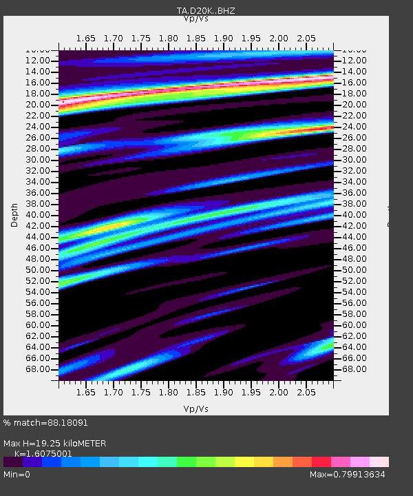
| Estimated Moho Depth: |
19.25 km |
| Estimated Crust Vp/Vs: |
1.61 |
| Assumed Crust Vp: |
6.221 km/s |
| Estimated Crust Vs: |
3.87 km/s |
| Estimated Crust Poisson's Ratio: |
0.18 |
|
| Radial Match: |
88.18091 % |
| Radial Bump: |
400 |
| Transverse Match: |
79.95768 % |
| Transverse Bump: |
400 |
| SOD ConfigId: |
13570011 |
| Insert Time: |
2019-05-01 14:56:34.851 +0000 |
| GWidth: |
2.5 |
| Max Bumps: |
400 |
| Tol: |
0.001 |
|

Signal To Noise
| Channel | StoN | STA | LTA |
| TA:D20K: :BHZ:20181025T23:05:56.675022Z | 8.451359 | 2.9372557E-6 | 3.4754834E-7 |
| TA:D20K: :BHN:20181025T23:05:56.675022Z | 6.0238075 | 1.1197894E-6 | 1.8589397E-7 |
| TA:D20K: :BHE:20181025T23:05:56.675022Z | 0.4908898 | 2.1729169E-7 | 4.4264863E-7 |
| Arrivals |
| Ps | 1.9 SECOND |
| PpPs | 7.8 SECOND |
| PsPs/PpSs | 9.7 SECOND |


