You are here: Home > Network List > TA - USArray Transportable Network (new EarthScope stations) Stations List
> Station D25K Kavik River, AK, USA > Earthquake Result Viewer
D25K Kavik River, AK, USA - Earthquake Result Viewer
| Earthquake location: |
Ionian Sea |
| Earthquake latitude/longitude: |
37.5/20.6 |
| Earthquake time(UTC): |
2018/10/25 (298) 22:54:52 GMT |
| Earthquake Depth: |
14 km |
| Earthquake Magnitude: |
6.8 Mww |
| Earthquake Catalog/Contributor: |
NEIC PDE/us |
|
| Network: |
TA USArray Transportable Network (new EarthScope stations) |
| Station: |
D25K Kavik River, AK, USA |
| Lat/Lon: |
69.32 N/146.38 W |
| Elevation: |
770 m |
|
| Distance: |
73.0 deg |
| Az: |
355.186 deg |
| Baz: |
10.829 deg |
| Ray Param: |
0.05325835 |
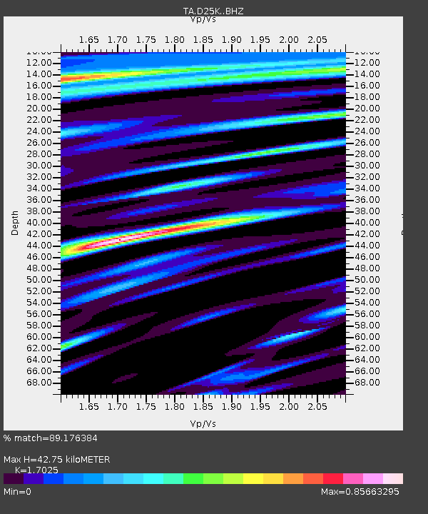
| Estimated Moho Depth: |
42.75 km |
| Estimated Crust Vp/Vs: |
1.70 |
| Assumed Crust Vp: |
6.378 km/s |
| Estimated Crust Vs: |
3.746 km/s |
| Estimated Crust Poisson's Ratio: |
0.24 |
|
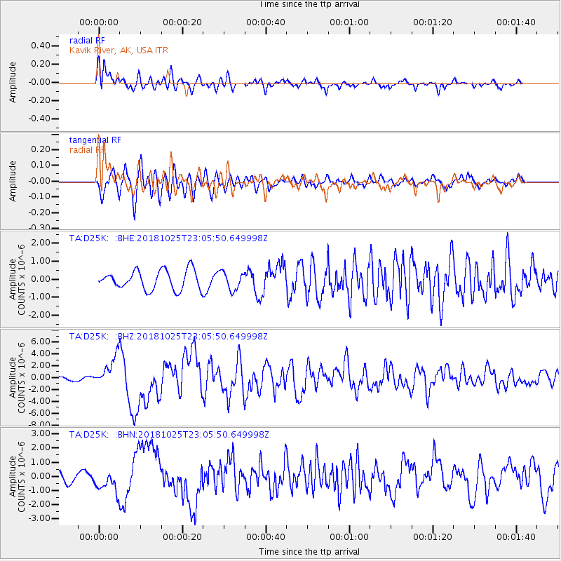
| Radial Match: |
89.176384 % |
| Radial Bump: |
400 |
| Transverse Match: |
76.2964 % |
| Transverse Bump: |
400 |
| SOD ConfigId: |
13570011 |
| Insert Time: |
2019-05-01 14:56:39.816 +0000 |
| GWidth: |
2.5 |
| Max Bumps: |
400 |
| Tol: |
0.001 |
|
Signal To Noise
| Channel | StoN | STA | LTA |
| TA:D25K: :BHZ:20181025T23:05:50.649998Z | 8.672785 | 2.6714317E-6 | 3.0802468E-7 |
| TA:D25K: :BHN:20181025T23:05:50.649998Z | 2.8003328 | 7.960841E-7 | 2.8428198E-7 |
| TA:D25K: :BHE:20181025T23:05:50.649998Z | 0.9360724 | 4.9808E-7 | 5.320956E-7 |
| Arrivals |
| Ps | 4.9 SECOND |
| PpPs | 17 SECOND |
| PsPs/PpSs | 22 SECOND |


