You are here: Home > Network List > TA - USArray Transportable Network (new EarthScope stations) Stations List
> Station F21K Alatna River, AK, USA > Earthquake Result Viewer
F21K Alatna River, AK, USA - Earthquake Result Viewer
| Earthquake location: |
Ionian Sea |
| Earthquake latitude/longitude: |
37.5/20.6 |
| Earthquake time(UTC): |
2018/10/25 (298) 22:54:52 GMT |
| Earthquake Depth: |
14 km |
| Earthquake Magnitude: |
6.8 Mww |
| Earthquake Catalog/Contributor: |
NEIC PDE/us |
|
| Network: |
TA USArray Transportable Network (new EarthScope stations) |
| Station: |
F21K Alatna River, AK, USA |
| Lat/Lon: |
67.22 N/153.48 W |
| Elevation: |
597 m |
|
| Distance: |
75.5 deg |
| Az: |
357.609 deg |
| Baz: |
4.887 deg |
| Ray Param: |
0.051627893 |
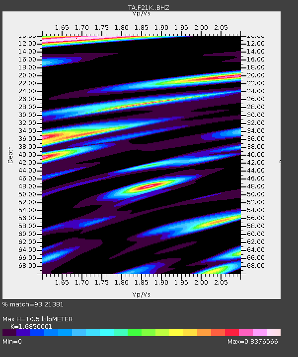
| Estimated Moho Depth: |
10.5 km |
| Estimated Crust Vp/Vs: |
1.69 |
| Assumed Crust Vp: |
6.455 km/s |
| Estimated Crust Vs: |
3.831 km/s |
| Estimated Crust Poisson's Ratio: |
0.23 |
|
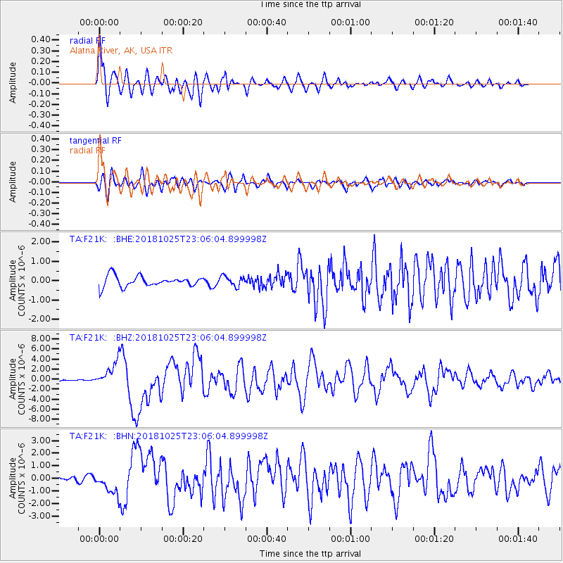
| Radial Match: |
93.21381 % |
| Radial Bump: |
400 |
| Transverse Match: |
87.38982 % |
| Transverse Bump: |
400 |
| SOD ConfigId: |
13570011 |
| Insert Time: |
2019-05-01 14:56:56.336 +0000 |
| GWidth: |
2.5 |
| Max Bumps: |
400 |
| Tol: |
0.001 |
|
Signal To Noise
| Channel | StoN | STA | LTA |
| TA:F21K: :BHZ:20181025T23:06:04.899998Z | 15.662121 | 2.5712823E-6 | 1.6417205E-7 |
| TA:F21K: :BHN:20181025T23:06:04.899998Z | 8.598659 | 9.381735E-7 | 1.09106956E-7 |
| TA:F21K: :BHE:20181025T23:06:04.899998Z | 0.956622 | 2.6431692E-7 | 2.7630236E-7 |
| Arrivals |
| Ps | 1.2 SECOND |
| PpPs | 4.2 SECOND |
| PsPs/PpSs | 5.4 SECOND |


