You are here: Home > Network List > TA - USArray Transportable Network (new EarthScope stations) Stations List
> Station N19A John Jarvie Ranch (BLM), Flaming Gorge, UT, USA > Earthquake Result Viewer
N19A John Jarvie Ranch (BLM), Flaming Gorge, UT, USA - Earthquake Result Viewer
| Earthquake location: |
Lake Baykal Region, Russia |
| Earthquake latitude/longitude: |
51.6/104.2 |
| Earthquake time(UTC): |
2008/08/27 (240) 01:35:32 GMT |
| Earthquake Depth: |
16 km |
| Earthquake Magnitude: |
5.8 MB, 6.2 MS, 6.2 MW, 6.2 MW |
| Earthquake Catalog/Contributor: |
WHDF/NEIC |
|
| Network: |
TA USArray Transportable Network (new EarthScope stations) |
| Station: |
N19A John Jarvie Ranch (BLM), Flaming Gorge, UT, USA |
| Lat/Lon: |
40.89 N/109.18 W |
| Elevation: |
1703 m |
|
| Distance: |
83.4 deg |
| Az: |
24.795 deg |
| Baz: |
339.819 deg |
| Ray Param: |
0.046200085 |
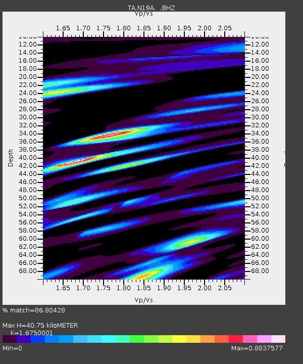
| Estimated Moho Depth: |
40.75 km |
| Estimated Crust Vp/Vs: |
1.68 |
| Assumed Crust Vp: |
6.207 km/s |
| Estimated Crust Vs: |
3.706 km/s |
| Estimated Crust Poisson's Ratio: |
0.22 |
|
| Radial Match: |
86.80428 % |
| Radial Bump: |
400 |
| Transverse Match: |
64.621376 % |
| Transverse Bump: |
400 |
| SOD ConfigId: |
2504 |
| Insert Time: |
2010-03-06 17:07:34.034 +0000 |
| GWidth: |
2.5 |
| Max Bumps: |
400 |
| Tol: |
0.001 |
|

Signal To Noise
| Channel | StoN | STA | LTA |
| TA:N19A: :BHZ:20080827T01:47:27.100012Z | 7.7310324 | 5.243063E-7 | 6.7818405E-8 |
| TA:N19A: :BHN:20080827T01:47:27.100012Z | 3.7476988 | 2.0516944E-7 | 5.4745446E-8 |
| TA:N19A: :BHE:20080827T01:47:27.100012Z | 1.0400385 | 5.53254E-8 | 5.319553E-8 |
| Arrivals |
| Ps | 4.5 SECOND |
| PpPs | 17 SECOND |
| PsPs/PpSs | 22 SECOND |


