You are here: Home > Network List > TA - USArray Transportable Network (new EarthScope stations) Stations List
> Station H17K Granite Mountain, AK, USA > Earthquake Result Viewer
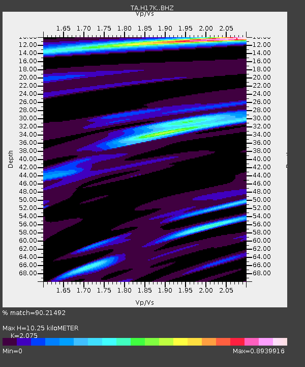
H17K Granite Mountain, AK, USA - Earthquake Result Viewer
| Earthquake location: |
Ionian Sea |
| Earthquake latitude/longitude: |
37.5/20.6 |
| Earthquake time(UTC): |
2018/10/25 (298) 22:54:52 GMT |
| Earthquake Depth: |
14 km |
| Earthquake Magnitude: |
6.8 Mww |
| Earthquake Catalog/Contributor: |
NEIC PDE/us |
|
| Network: |
TA USArray Transportable Network (new EarthScope stations) |
| Station: |
H17K Granite Mountain, AK, USA |
| Lat/Lon: |
64.94 N/159.91 W |
| Elevation: |
396 m |
|
| Distance: |
77.9 deg |
| Az: |
0.207 deg |
| Baz: |
359.613 deg |
| Ray Param: |
0.050013296 |
| Estimated Moho Depth: |
10.25 km |
| Estimated Crust Vp/Vs: |
2.08 |
| Assumed Crust Vp: |
6.1 km/s |
| Estimated Crust Vs: |
2.94 km/s |
| Estimated Crust Poisson's Ratio: |
0.35 |
|
| Radial Match: |
90.21492 % |
| Radial Bump: |
400 |
| Transverse Match: |
72.453964 % |
| Transverse Bump: |
400 |
| SOD ConfigId: |
13570011 |
| Insert Time: |
2019-05-01 14:57:15.686 +0000 |
| GWidth: |
2.5 |
| Max Bumps: |
400 |
| Tol: |
0.001 |
|

Signal To Noise
| Channel | StoN | STA | LTA |
| TA:H17K: :BHZ:20181025T23:06:18.374973Z | 5.911859 | 2.6754526E-6 | 4.525569E-7 |
| TA:H17K: :BHN:20181025T23:06:18.374973Z | 3.620187 | 1.1666289E-6 | 3.222565E-7 |
| TA:H17K: :BHE:20181025T23:06:18.374973Z | 0.8373792 | 3.4003344E-7 | 4.0606864E-7 |
| Arrivals |
| Ps | 1.8 SECOND |
| PpPs | 5.0 SECOND |
| PsPs/PpSs | 6.9 SECOND |


