You are here: Home > Network List > TA - USArray Transportable Network (new EarthScope stations) Stations List
> Station N19A John Jarvie Ranch (BLM), Flaming Gorge, UT, USA > Earthquake Result Viewer
N19A John Jarvie Ranch (BLM), Flaming Gorge, UT, USA - Earthquake Result Viewer
| Earthquake location: |
Colombia |
| Earthquake latitude/longitude: |
4.8/-75.5 |
| Earthquake time(UTC): |
2008/09/13 (257) 09:32:01 GMT |
| Earthquake Depth: |
133 km |
| Earthquake Magnitude: |
5.9 MB, 5.7 MW, 5.7 MW |
| Earthquake Catalog/Contributor: |
WHDF/NEIC |
|
| Network: |
TA USArray Transportable Network (new EarthScope stations) |
| Station: |
N19A John Jarvie Ranch (BLM), Flaming Gorge, UT, USA |
| Lat/Lon: |
40.89 N/109.18 W |
| Elevation: |
1703 m |
|
| Distance: |
46.9 deg |
| Az: |
324.886 deg |
| Baz: |
130.875 deg |
| Ray Param: |
0.069850005 |
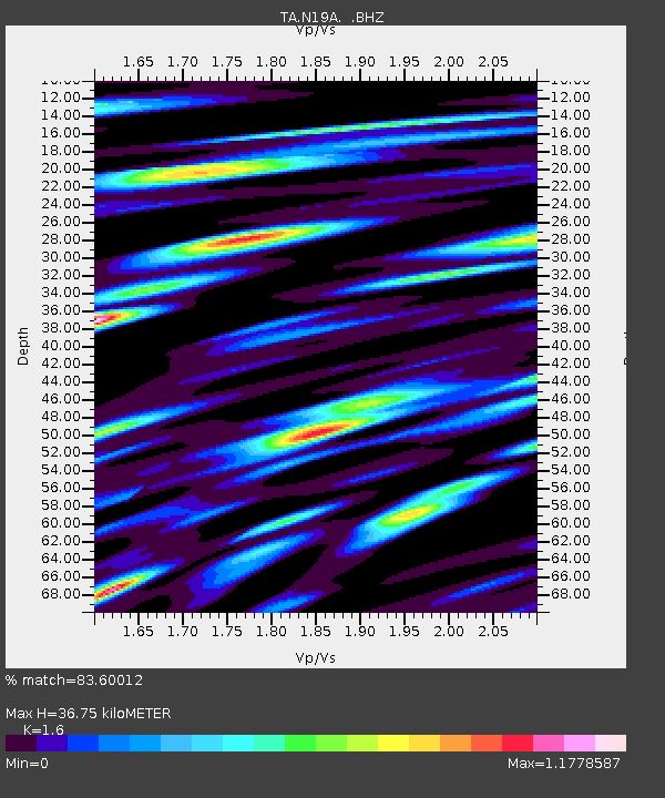
| Estimated Moho Depth: |
36.75 km |
| Estimated Crust Vp/Vs: |
1.60 |
| Assumed Crust Vp: |
6.207 km/s |
| Estimated Crust Vs: |
3.879 km/s |
| Estimated Crust Poisson's Ratio: |
0.18 |
|
| Radial Match: |
83.60012 % |
| Radial Bump: |
400 |
| Transverse Match: |
72.52074 % |
| Transverse Bump: |
400 |
| SOD ConfigId: |
2560 |
| Insert Time: |
2010-03-06 17:07:51.201 +0000 |
| GWidth: |
2.5 |
| Max Bumps: |
400 |
| Tol: |
0.001 |
|

Signal To Noise
| Channel | StoN | STA | LTA |
| TA:N19A: :BHZ:20080913T09:39:48.224009Z | 12.427514 | 1.4110847E-6 | 1.13545205E-7 |
| TA:N19A: :BHN:20080913T09:39:48.224009Z | 16.881937 | 1.2139647E-6 | 7.190909E-8 |
| TA:N19A: :BHE:20080913T09:39:48.224009Z | 13.681687 | 1.1261269E-6 | 8.2309064E-8 |
| Arrivals |
| Ps | 3.8 SECOND |
| PpPs | 14 SECOND |
| PsPs/PpSs | 18 SECOND |


