You are here: Home > Network List > TA - USArray Transportable Network (new EarthScope stations) Stations List
> Station N19A John Jarvie Ranch (BLM), Flaming Gorge, UT, USA > Earthquake Result Viewer
N19A John Jarvie Ranch (BLM), Flaming Gorge, UT, USA - Earthquake Result Viewer
| Earthquake location: |
Kermadec Islands, New Zealand |
| Earthquake latitude/longitude: |
-29.8/-177.7 |
| Earthquake time(UTC): |
2008/09/29 (273) 15:19:31 GMT |
| Earthquake Depth: |
36 km |
| Earthquake Magnitude: |
6.5 MB, 6.7 MS, 7.0 MW, 7.0 MW |
| Earthquake Catalog/Contributor: |
WHDF/NEIC |
|
| Network: |
TA USArray Transportable Network (new EarthScope stations) |
| Station: |
N19A John Jarvie Ranch (BLM), Flaming Gorge, UT, USA |
| Lat/Lon: |
40.89 N/109.18 W |
| Elevation: |
1703 m |
|
| Distance: |
94.6 deg |
| Az: |
45.046 deg |
| Baz: |
234.266 deg |
| Ray Param: |
0.04098387 |
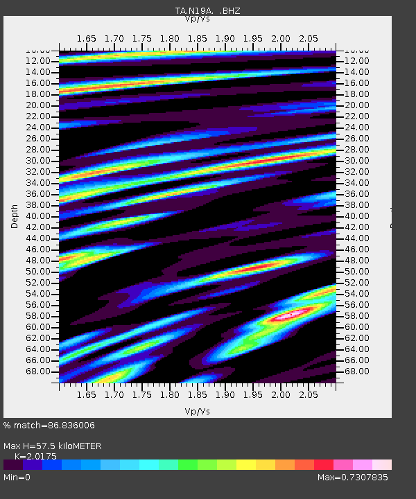
| Estimated Moho Depth: |
57.5 km |
| Estimated Crust Vp/Vs: |
2.02 |
| Assumed Crust Vp: |
6.207 km/s |
| Estimated Crust Vs: |
3.077 km/s |
| Estimated Crust Poisson's Ratio: |
0.34 |
|
| Radial Match: |
86.836006 % |
| Radial Bump: |
400 |
| Transverse Match: |
77.89264 % |
| Transverse Bump: |
400 |
| SOD ConfigId: |
2560 |
| Insert Time: |
2010-03-06 17:07:52.088 +0000 |
| GWidth: |
2.5 |
| Max Bumps: |
400 |
| Tol: |
0.001 |
|

Signal To Noise
| Channel | StoN | STA | LTA |
| TA:N19A: :BHZ:20080929T15:32:17.324009Z | 6.251612 | 5.2527975E-7 | 8.402308E-8 |
| TA:N19A: :BHN:20080929T15:32:17.324009Z | 0.84551436 | 8.6208566E-8 | 1.01959905E-7 |
| TA:N19A: :BHE:20080929T15:32:17.324009Z | 1.6153873 | 1.552456E-7 | 9.610426E-8 |
| Arrivals |
| Ps | 9.6 SECOND |
| PpPs | 27 SECOND |
| PsPs/PpSs | 37 SECOND |


