You are here: Home > Network List > TA - USArray Transportable Network (new EarthScope stations) Stations List
> Station N17K Nushagak Hills, AK, USA > Earthquake Result Viewer
N17K Nushagak Hills, AK, USA - Earthquake Result Viewer
| Earthquake location: |
Ionian Sea |
| Earthquake latitude/longitude: |
37.5/20.6 |
| Earthquake time(UTC): |
2018/10/25 (298) 22:54:52 GMT |
| Earthquake Depth: |
14 km |
| Earthquake Magnitude: |
6.8 Mww |
| Earthquake Catalog/Contributor: |
NEIC PDE/us |
|
| Network: |
TA USArray Transportable Network (new EarthScope stations) |
| Station: |
N17K Nushagak Hills, AK, USA |
| Lat/Lon: |
60.53 N/157.19 W |
| Elevation: |
350 m |
|
| Distance: |
82.3 deg |
| Az: |
358.877 deg |
| Baz: |
1.805 deg |
| Ray Param: |
0.046981625 |
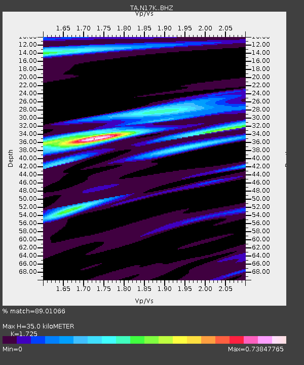
| Estimated Moho Depth: |
35.0 km |
| Estimated Crust Vp/Vs: |
1.73 |
| Assumed Crust Vp: |
6.155 km/s |
| Estimated Crust Vs: |
3.568 km/s |
| Estimated Crust Poisson's Ratio: |
0.25 |
|
| Radial Match: |
89.01066 % |
| Radial Bump: |
396 |
| Transverse Match: |
73.03953 % |
| Transverse Bump: |
400 |
| SOD ConfigId: |
13570011 |
| Insert Time: |
2019-05-01 14:58:04.613 +0000 |
| GWidth: |
2.5 |
| Max Bumps: |
400 |
| Tol: |
0.001 |
|

Signal To Noise
| Channel | StoN | STA | LTA |
| TA:N17K: :BHZ:20181025T23:06:42.10001Z | 6.1138372 | 1.8173428E-6 | 2.9725075E-7 |
| TA:N17K: :BHN:20181025T23:06:42.10001Z | 1.8944284 | 6.1398924E-7 | 3.2410261E-7 |
| TA:N17K: :BHE:20181025T23:06:42.10001Z | 0.96845645 | 3.4583232E-7 | 3.570964E-7 |
| Arrivals |
| Ps | 4.2 SECOND |
| PpPs | 15 SECOND |
| PsPs/PpSs | 19 SECOND |


