You are here: Home > Network List > TA - USArray Transportable Network (new EarthScope stations) Stations List
> Station O14K Tigyukauivet Mountain, AK, USA > Earthquake Result Viewer
O14K Tigyukauivet Mountain, AK, USA - Earthquake Result Viewer
| Earthquake location: |
Ionian Sea |
| Earthquake latitude/longitude: |
37.5/20.6 |
| Earthquake time(UTC): |
2018/10/25 (298) 22:54:52 GMT |
| Earthquake Depth: |
14 km |
| Earthquake Magnitude: |
6.8 Mww |
| Earthquake Catalog/Contributor: |
NEIC PDE/us |
|
| Network: |
TA USArray Transportable Network (new EarthScope stations) |
| Station: |
O14K Tigyukauivet Mountain, AK, USA |
| Lat/Lon: |
59.25 N/161.26 W |
| Elevation: |
129 m |
|
| Distance: |
83.6 deg |
| Az: |
0.945 deg |
| Baz: |
358.538 deg |
| Ray Param: |
0.046083573 |
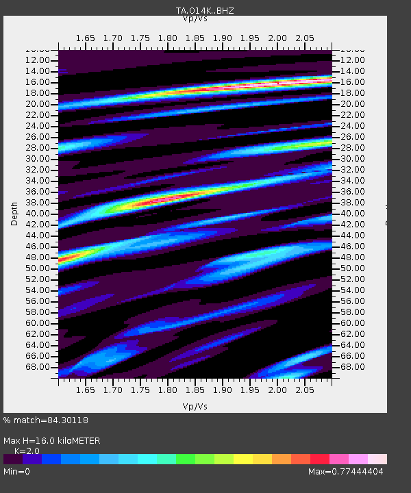
| Estimated Moho Depth: |
16.0 km |
| Estimated Crust Vp/Vs: |
2.00 |
| Assumed Crust Vp: |
6.24 km/s |
| Estimated Crust Vs: |
3.12 km/s |
| Estimated Crust Poisson's Ratio: |
0.33 |
|
| Radial Match: |
84.30118 % |
| Radial Bump: |
400 |
| Transverse Match: |
68.16422 % |
| Transverse Bump: |
400 |
| SOD ConfigId: |
13570011 |
| Insert Time: |
2019-05-01 14:58:14.639 +0000 |
| GWidth: |
2.5 |
| Max Bumps: |
400 |
| Tol: |
0.001 |
|

Signal To Noise
| Channel | StoN | STA | LTA |
| TA:O14K: :BHZ:20181025T23:06:48.72501Z | 7.6499968 | 2.3620732E-6 | 3.0876788E-7 |
| TA:O14K: :BHN:20181025T23:06:48.72501Z | 2.8272495 | 1.1273526E-6 | 3.9874536E-7 |
| TA:O14K: :BHE:20181025T23:06:48.72501Z | 0.59661937 | 1.9474982E-7 | 3.264222E-7 |
| Arrivals |
| Ps | 2.6 SECOND |
| PpPs | 7.5 SECOND |
| PsPs/PpSs | 10 SECOND |


