You are here: Home > Network List > TA - USArray Transportable Network (new EarthScope stations) Stations List
> Station N19A John Jarvie Ranch (BLM), Flaming Gorge, UT, USA > Earthquake Result Viewer
N19A John Jarvie Ranch (BLM), Flaming Gorge, UT, USA - Earthquake Result Viewer
| Earthquake location: |
Andreanof Islands, Aleutian Is. |
| Earthquake latitude/longitude: |
52.2/-178.7 |
| Earthquake time(UTC): |
2008/03/22 (082) 21:24:11 GMT |
| Earthquake Depth: |
132 km |
| Earthquake Magnitude: |
5.8 MB, 6.2 MW, 6.1 MW |
| Earthquake Catalog/Contributor: |
WHDF/NEIC |
|
| Network: |
TA USArray Transportable Network (new EarthScope stations) |
| Station: |
N19A John Jarvie Ranch (BLM), Flaming Gorge, UT, USA |
| Lat/Lon: |
40.89 N/109.18 W |
| Elevation: |
1703 m |
|
| Distance: |
47.4 deg |
| Az: |
74.814 deg |
| Baz: |
308.377 deg |
| Ray Param: |
0.06956951 |
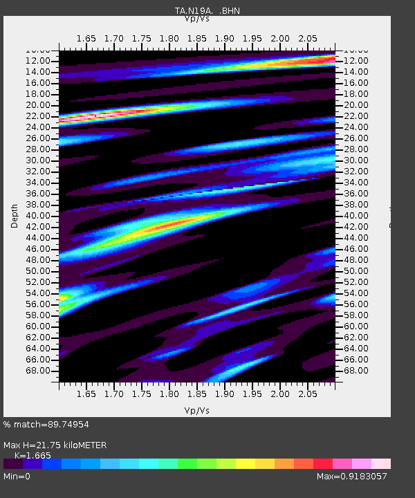
| Estimated Moho Depth: |
21.75 km |
| Estimated Crust Vp/Vs: |
1.66 |
| Assumed Crust Vp: |
6.207 km/s |
| Estimated Crust Vs: |
3.728 km/s |
| Estimated Crust Poisson's Ratio: |
0.22 |
|
| Radial Match: |
89.74954 % |
| Radial Bump: |
362 |
| Transverse Match: |
75.23623 % |
| Transverse Bump: |
400 |
| SOD ConfigId: |
2564 |
| Insert Time: |
2010-03-06 17:07:54.379 +0000 |
| GWidth: |
2.5 |
| Max Bumps: |
400 |
| Tol: |
0.001 |
|

Signal To Noise
| Channel | StoN | STA | LTA |
| TA:N19A: :BHN:20080322T21:32:01.650005Z | 6.795069 | 1.0776317E-6 | 1.5859025E-7 |
| TA:N19A: :BHE:20080322T21:32:01.650005Z | 7.606135 | 1.0513796E-6 | 1.3822783E-7 |
| TA:N19A: :BHZ:20080322T21:32:01.650005Z | 16.432169 | 2.2626625E-6 | 1.3769713E-7 |
| Arrivals |
| Ps | 2.5 SECOND |
| PpPs | 8.8 SECOND |
| PsPs/PpSs | 11 SECOND |


