You are here: Home > Network List > TJ - Tajikistan National Seismic Network Stations List
> Station SHAA Shaartuz, Tajikistan > Earthquake Result Viewer
SHAA Shaartuz, Tajikistan - Earthquake Result Viewer
| Earthquake location: |
Ionian Sea |
| Earthquake latitude/longitude: |
37.5/20.6 |
| Earthquake time(UTC): |
2018/10/25 (298) 22:54:52 GMT |
| Earthquake Depth: |
14 km |
| Earthquake Magnitude: |
6.8 Mww |
| Earthquake Catalog/Contributor: |
NEIC PDE/us |
|
| Network: |
TJ Tajikistan National Seismic Network |
| Station: |
SHAA Shaartuz, Tajikistan |
| Lat/Lon: |
37.56 N/68.12 E |
| Elevation: |
868 m |
|
| Distance: |
37.4 deg |
| Az: |
74.965 deg |
| Baz: |
284.9 deg |
| Ray Param: |
0.07615258 |
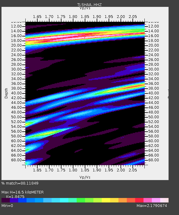
| Estimated Moho Depth: |
16.5 km |
| Estimated Crust Vp/Vs: |
1.85 |
| Assumed Crust Vp: |
6.213 km/s |
| Estimated Crust Vs: |
3.363 km/s |
| Estimated Crust Poisson's Ratio: |
0.29 |
|
| Radial Match: |
88.11849 % |
| Radial Bump: |
400 |
| Transverse Match: |
74.004 % |
| Transverse Bump: |
400 |
| SOD ConfigId: |
13570011 |
| Insert Time: |
2019-05-01 14:58:51.520 +0000 |
| GWidth: |
2.5 |
| Max Bumps: |
400 |
| Tol: |
0.001 |
|

Signal To Noise
| Channel | StoN | STA | LTA |
| TJ:SHAA: :HHZ:20181025T23:01:34.060001Z | 48.39332 | 1.11236095E-5 | 2.2985837E-7 |
| TJ:SHAA: :HHN:20181025T23:01:34.060001Z | 7.5256467 | 1.050149E-6 | 1.3954269E-7 |
| TJ:SHAA: :HHE:20181025T23:01:34.060001Z | 21.595623 | 5.127432E-6 | 2.3742922E-7 |
| Arrivals |
| Ps | 2.4 SECOND |
| PpPs | 7.1 SECOND |
| PsPs/PpSs | 9.5 SECOND |


