You are here: Home > Network List > TA - USArray Transportable Network (new EarthScope stations) Stations List
> Station N19A John Jarvie Ranch (BLM), Flaming Gorge, UT, USA > Earthquake Result Viewer
N19A John Jarvie Ranch (BLM), Flaming Gorge, UT, USA - Earthquake Result Viewer

| Earthquake location: |
South Of Fiji Islands |
| Earthquake latitude/longitude: |
-26.0/-177.5 |
| Earthquake time(UTC): |
2007/12/09 (343) 07:28:20 GMT |
| Earthquake Depth: |
152 km |
| Earthquake Magnitude: |
7.0 MB, 7.8 MW, 7.7 MW |
| Earthquake Catalog/Contributor: |
WHDF/NEIC |
|
| Network: |
TA USArray Transportable Network (new EarthScope stations) |
| Station: |
N19A John Jarvie Ranch (BLM), Flaming Gorge, UT, USA |
| Lat/Lon: |
40.89 N/109.18 W |
| Elevation: |
1703 m |
|
| Distance: |
91.9 deg |
| Az: |
44.823 deg |
| Baz: |
236.809 deg |
| Ray Param: |
0.04147821 |
| Estimated Moho Depth: |
69.75 km |
| Estimated Crust Vp/Vs: |
1.86 |
| Assumed Crust Vp: |
6.207 km/s |
| Estimated Crust Vs: |
3.346 km/s |
| Estimated Crust Poisson's Ratio: |
0.30 |
|
| Radial Match: |
94.98151 % |
| Radial Bump: |
400 |
| Transverse Match: |
82.64607 % |
| Transverse Bump: |
400 |
| SOD ConfigId: |
2564 |
| Insert Time: |
2010-03-06 17:08:06.060 +0000 |
| GWidth: |
2.5 |
| Max Bumps: |
400 |
| Tol: |
0.001 |
|
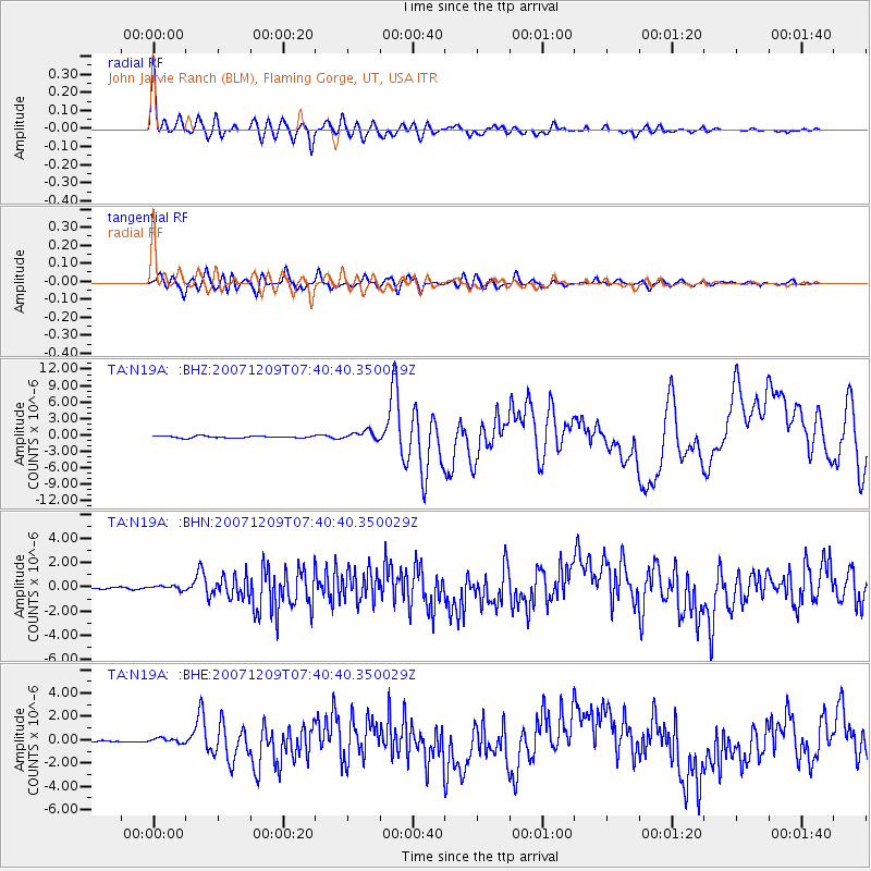
Signal To Noise
| Channel | StoN | STA | LTA |
| TA:N19A: :BHN:20071209T07:40:40.350029Z | 0.9041828 | 1.644008E-7 | 1.8182253E-7 |
| TA:N19A: :BHE:20071209T07:40:40.350029Z | 1.9364384 | 2.2443359E-7 | 1.159002E-7 |
| TA:N19A: :BHZ:20071209T07:40:40.350029Z | 4.621476 | 8.015149E-7 | 1.7343265E-7 |
| Arrivals |
| Ps | 9.8 SECOND |
| PpPs | 32 SECOND |
| PsPs/PpSs | 41 SECOND |


