You are here: Home > Network List > TA - USArray Transportable Network (new EarthScope stations) Stations List
> Station N19A John Jarvie Ranch (BLM), Flaming Gorge, UT, USA > Earthquake Result Viewer
N19A John Jarvie Ranch (BLM), Flaming Gorge, UT, USA - Earthquake Result Viewer
| Earthquake location: |
South Of Fiji Islands |
| Earthquake latitude/longitude: |
-25.8/179.5 |
| Earthquake time(UTC): |
2007/10/16 (289) 21:05:43 GMT |
| Earthquake Depth: |
509 km |
| Earthquake Magnitude: |
6.2 MB, 6.6 MW, 6.5 MW |
| Earthquake Catalog/Contributor: |
WHDF/NEIC |
|
| Network: |
TA USArray Transportable Network (new EarthScope stations) |
| Station: |
N19A John Jarvie Ranch (BLM), Flaming Gorge, UT, USA |
| Lat/Lon: |
40.89 N/109.18 W |
| Elevation: |
1703 m |
|
| Distance: |
93.6 deg |
| Az: |
46.011 deg |
| Baz: |
238.837 deg |
| Ray Param: |
0.04078273 |
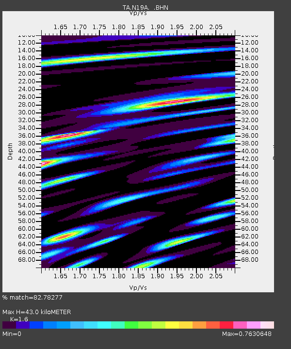
| Estimated Moho Depth: |
43.0 km |
| Estimated Crust Vp/Vs: |
1.60 |
| Assumed Crust Vp: |
6.207 km/s |
| Estimated Crust Vs: |
3.879 km/s |
| Estimated Crust Poisson's Ratio: |
0.18 |
|
| Radial Match: |
82.78277 % |
| Radial Bump: |
400 |
| Transverse Match: |
74.29836 % |
| Transverse Bump: |
400 |
| SOD ConfigId: |
2564 |
| Insert Time: |
2010-03-06 17:08:24.282 +0000 |
| GWidth: |
2.5 |
| Max Bumps: |
400 |
| Tol: |
0.001 |
|

Signal To Noise
| Channel | StoN | STA | LTA |
| TA:N19A: :BHN:20071016T21:17:33.175029Z | 3.8787916 | 3.258375E-7 | 8.40049E-8 |
| TA:N19A: :BHE:20071016T21:17:33.175029Z | 4.8486853 | 4.8167936E-7 | 9.9342266E-8 |
| TA:N19A: :BHZ:20071016T21:17:33.175029Z | 17.543806 | 1.7532341E-6 | 9.9934645E-8 |
| Arrivals |
| Ps | 4.2 SECOND |
| PpPs | 18 SECOND |
| PsPs/PpSs | 22 SECOND |


