You are here: Home > Network List > UU - University of Utah Regional Network Stations List
> Station FORU South Mineral Mountains, UT, USA > Earthquake Result Viewer
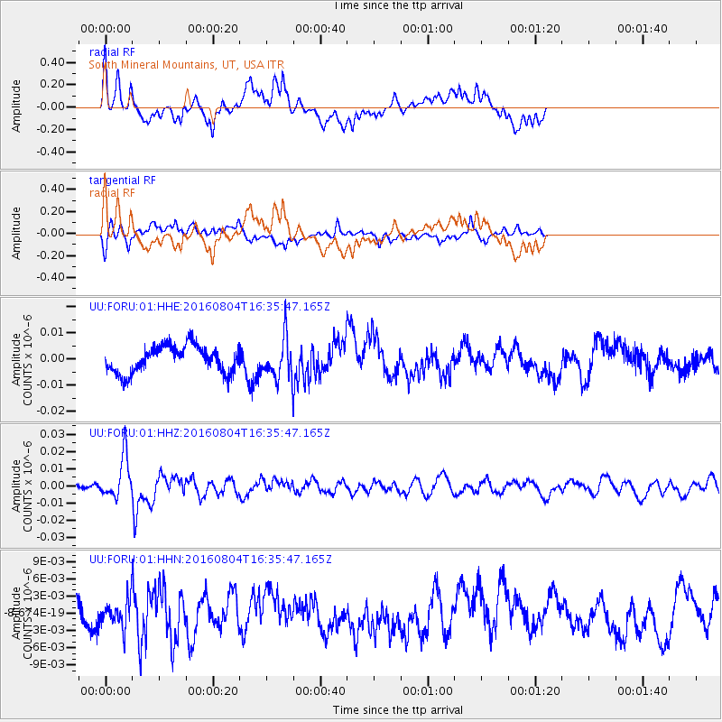
FORU South Mineral Mountains, UT, USA - Earthquake Result Viewer
*The percent match for this event was below the threshold and hence no stack was calculated.
| Earthquake location: |
Volcano Islands, Japan Region |
| Earthquake latitude/longitude: |
24.9/142.0 |
| Earthquake time(UTC): |
2016/08/04 (217) 16:24:33 GMT |
| Earthquake Depth: |
510 km |
| Earthquake Magnitude: |
6.3 MWW, 6.2 MWC, 6.3 MWB, 6.3 MWC |
| Earthquake Catalog/Contributor: |
NEIC PDE/NEIC COMCAT |
|
| Network: |
UU University of Utah Regional Network |
| Station: |
FORU South Mineral Mountains, UT, USA |
| Lat/Lon: |
38.46 N/112.86 W |
| Elevation: |
1840 m |
|
| Distance: |
85.8 deg |
| Az: |
49.459 deg |
| Baz: |
298.515 deg |
| Ray Param: |
$rayparam |
*The percent match for this event was below the threshold and hence was not used in the summary stack. |
|
| Radial Match: |
74.996475 % |
| Radial Bump: |
392 |
| Transverse Match: |
49.30833 % |
| Transverse Bump: |
384 |
| SOD ConfigId: |
1634031 |
| Insert Time: |
2016-08-18 16:28:19.031 +0000 |
| GWidth: |
2.5 |
| Max Bumps: |
400 |
| Tol: |
0.001 |
|
Signal To Noise
| Channel | StoN | STA | LTA |
| UU:FORU:01:HHZ:20160804T16:35:47.165Z | 4.5737376 | 1.2555333E-8 | 2.7450924E-9 |
| UU:FORU:01:HHN:20160804T16:35:47.165Z | 1.1068969 | 2.2343236E-9 | 2.018547E-9 |
| UU:FORU:01:HHE:20160804T16:35:47.165Z | 1.4420408 | 7.3684285E-9 | 5.109723E-9 |
| Arrivals |
| Ps | |
| PpPs | |
| PsPs/PpSs | |


