You are here: Home > Network List > TA - USArray Transportable Network (new EarthScope stations) Stations List
> Station N19A John Jarvie Ranch (BLM), Flaming Gorge, UT, USA > Earthquake Result Viewer
N19A John Jarvie Ranch (BLM), Flaming Gorge, UT, USA - Earthquake Result Viewer
| Earthquake location: |
Northern Mid-Atlantic Ridge |
| Earthquake latitude/longitude: |
47.0/-27.3 |
| Earthquake time(UTC): |
2008/12/19 (354) 08:31:51 GMT |
| Earthquake Depth: |
2.0 km |
| Earthquake Magnitude: |
5.8 MB, 5.6 MS, 5.9 MW, 5.8 MW |
| Earthquake Catalog/Contributor: |
WHDF/NEIC |
|
| Network: |
TA USArray Transportable Network (new EarthScope stations) |
| Station: |
N19A John Jarvie Ranch (BLM), Flaming Gorge, UT, USA |
| Lat/Lon: |
40.89 N/109.18 W |
| Elevation: |
1703 m |
|
| Distance: |
56.7 deg |
| Az: |
296.142 deg |
| Baz: |
54.142 deg |
| Ray Param: |
0.063973844 |
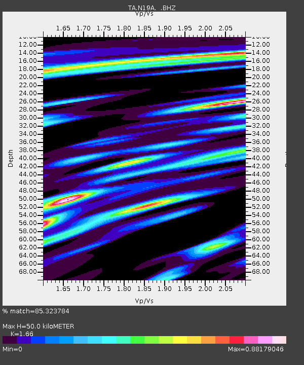
| Estimated Moho Depth: |
50.0 km |
| Estimated Crust Vp/Vs: |
1.66 |
| Assumed Crust Vp: |
6.207 km/s |
| Estimated Crust Vs: |
3.739 km/s |
| Estimated Crust Poisson's Ratio: |
0.22 |
|
| Radial Match: |
85.323784 % |
| Radial Bump: |
400 |
| Transverse Match: |
73.24223 % |
| Transverse Bump: |
400 |
| SOD ConfigId: |
2658 |
| Insert Time: |
2010-03-06 17:08:39.737 +0000 |
| GWidth: |
2.5 |
| Max Bumps: |
400 |
| Tol: |
0.001 |
|

Signal To Noise
| Channel | StoN | STA | LTA |
| TA:N19A: :BHZ:20081219T08:41:05.025005Z | 7.3103704 | 7.3635016E-7 | 1.00726794E-7 |
| TA:N19A: :BHN:20081219T08:41:05.025005Z | 3.1640575 | 3.4304458E-7 | 1.084192E-7 |
| TA:N19A: :BHE:20081219T08:41:05.025005Z | 3.7213347 | 4.2403093E-7 | 1.1394592E-7 |
| Arrivals |
| Ps | 5.6 SECOND |
| PpPs | 20 SECOND |
| PsPs/PpSs | 26 SECOND |


