You are here: Home > Network List > TA - USArray Transportable Network (new EarthScope stations) Stations List
> Station N19A John Jarvie Ranch (BLM), Flaming Gorge, UT, USA > Earthquake Result Viewer
N19A John Jarvie Ranch (BLM), Flaming Gorge, UT, USA - Earthquake Result Viewer

| Earthquake location: |
Near Coast Of Northern Peru |
| Earthquake latitude/longitude: |
-6.6/-81.2 |
| Earthquake time(UTC): |
2009/02/09 (040) 14:09:02 GMT |
| Earthquake Depth: |
15 km |
| Earthquake Magnitude: |
5.5 MB, 5.5 MS, 6.0 MW, 5.9 MW |
| Earthquake Catalog/Contributor: |
WHDF/NEIC |
|
| Network: |
TA USArray Transportable Network (new EarthScope stations) |
| Station: |
N19A John Jarvie Ranch (BLM), Flaming Gorge, UT, USA |
| Lat/Lon: |
40.89 N/109.18 W |
| Elevation: |
1703 m |
|
| Distance: |
53.8 deg |
| Az: |
333.8 deg |
| Baz: |
144.647 deg |
| Ray Param: |
0.06585255 |
| Estimated Moho Depth: |
45.75 km |
| Estimated Crust Vp/Vs: |
2.03 |
| Assumed Crust Vp: |
6.207 km/s |
| Estimated Crust Vs: |
3.058 km/s |
| Estimated Crust Poisson's Ratio: |
0.34 |
|
| Radial Match: |
85.821884 % |
| Radial Bump: |
400 |
| Transverse Match: |
53.33076 % |
| Transverse Bump: |
400 |
| SOD ConfigId: |
2658 |
| Insert Time: |
2010-03-06 17:08:44.776 +0000 |
| GWidth: |
2.5 |
| Max Bumps: |
400 |
| Tol: |
0.001 |
|
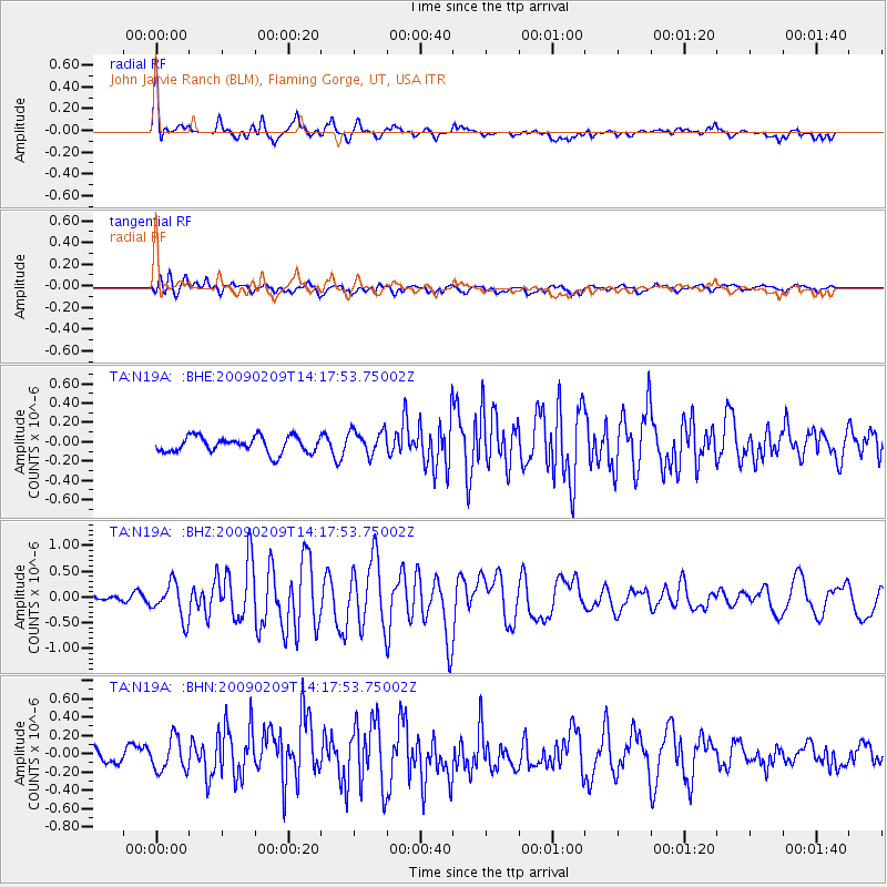
Signal To Noise
| Channel | StoN | STA | LTA |
| TA:N19A: :BHZ:20090209T14:17:53.75002Z | 5.077314 | 3.454514E-7 | 6.803822E-8 |
| TA:N19A: :BHN:20090209T14:17:53.75002Z | 2.1133606 | 1.7913855E-7 | 8.4764785E-8 |
| TA:N19A: :BHE:20090209T14:17:53.75002Z | 1.5482411 | 1.2768147E-7 | 8.246872E-8 |
| Arrivals |
| Ps | 7.9 SECOND |
| PpPs | 21 SECOND |
| PsPs/PpSs | 29 SECOND |


