You are here: Home > Network List > TA - USArray Transportable Network (new EarthScope stations) Stations List
> Station N19A John Jarvie Ranch (BLM), Flaming Gorge, UT, USA > Earthquake Result Viewer
N19A John Jarvie Ranch (BLM), Flaming Gorge, UT, USA - Earthquake Result Viewer
| Earthquake location: |
Kuril Islands |
| Earthquake latitude/longitude: |
50.8/155.0 |
| Earthquake time(UTC): |
2009/04/21 (111) 05:26:11 GMT |
| Earthquake Depth: |
152 km |
| Earthquake Magnitude: |
6.0 MB, 6.2 MW, 6.2 MW |
| Earthquake Catalog/Contributor: |
WHDF/NEIC |
|
| Network: |
TA USArray Transportable Network (new EarthScope stations) |
| Station: |
N19A John Jarvie Ranch (BLM), Flaming Gorge, UT, USA |
| Lat/Lon: |
40.89 N/109.18 W |
| Elevation: |
1703 m |
|
| Distance: |
62.9 deg |
| Az: |
57.91 deg |
| Baz: |
314.873 deg |
| Ray Param: |
0.05948226 |
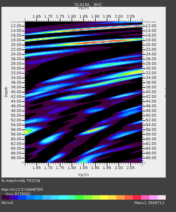
| Estimated Moho Depth: |
12.5 km |
| Estimated Crust Vp/Vs: |
1.97 |
| Assumed Crust Vp: |
6.207 km/s |
| Estimated Crust Vs: |
3.147 km/s |
| Estimated Crust Poisson's Ratio: |
0.33 |
|
| Radial Match: |
86.793236 % |
| Radial Bump: |
400 |
| Transverse Match: |
81.587715 % |
| Transverse Bump: |
400 |
| SOD ConfigId: |
2760 |
| Insert Time: |
2010-03-06 17:08:54.176 +0000 |
| GWidth: |
2.5 |
| Max Bumps: |
400 |
| Tol: |
0.001 |
|

Signal To Noise
| Channel | StoN | STA | LTA |
| TA:N19A: :BHZ:20090421T05:35:50.749004Z | 21.056627 | 1.2691096E-6 | 6.027127E-8 |
| TA:N19A: :BHN:20090421T05:35:50.749004Z | 8.0892315 | 6.1195175E-7 | 7.565018E-8 |
| TA:N19A: :BHE:20090421T05:35:50.749004Z | 14.107715 | 6.352396E-7 | 4.5027814E-8 |
| Arrivals |
| Ps | 2.0 SECOND |
| PpPs | 5.8 SECOND |
| PsPs/PpSs | 7.8 SECOND |


