You are here: Home > Network List > TS - TERRAscope (Southern California Seismic Network) Stations List
> Station BAR Barrett Dam, California, USA > Earthquake Result Viewer
BAR Barrett Dam, California, USA - Earthquake Result Viewer
*The percent match for this event was below the threshold and hence no stack was calculated.
| Earthquake location: |
Fiji Islands Region |
| Earthquake latitude/longitude: |
-20.9/-179.2 |
| Earthquake time(UTC): |
1995/01/17 (017) 16:54:12 GMT |
| Earthquake Depth: |
637 km |
| Earthquake Magnitude: |
6.0 MB, 6.2 UNKNOWN, 6.4 MW |
| Earthquake Catalog/Contributor: |
WHDF/NEIC |
|
| Network: |
TS TERRAscope (Southern California Seismic Network) |
| Station: |
BAR Barrett Dam, California, USA |
| Lat/Lon: |
32.68 N/116.67 W |
| Elevation: |
548 m |
|
| Distance: |
80.0 deg |
| Az: |
49.455 deg |
| Baz: |
237.421 deg |
| Ray Param: |
$rayparam |
*The percent match for this event was below the threshold and hence was not used in the summary stack. |
|
| Radial Match: |
61.770943 % |
| Radial Bump: |
400 |
| Transverse Match: |
59.44637 % |
| Transverse Bump: |
386 |
| SOD ConfigId: |
4480 |
| Insert Time: |
2010-02-26 13:59:31.222 +0000 |
| GWidth: |
2.5 |
| Max Bumps: |
400 |
| Tol: |
0.001 |
|
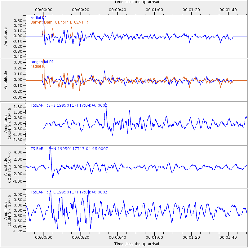
Signal To Noise
| Channel | StoN | STA | LTA |
| TS:BAR: :BHN:19950117T17:04:46.000Z | 6.567987 | 2.0892653E-6 | 3.1809827E-7 |
| TS:BAR: :BHE:19950117T17:04:46.000Z | 2.1453874 | 4.892593E-7 | 2.2805172E-7 |
| TS:BAR: :BHZ:19950117T17:04:46.000Z | 2.695794 | 6.88142E-7 | 2.5526504E-7 |
| Arrivals |
| Ps | |
| PpPs | |
| PsPs/PpSs | |


