You are here: Home > Network List > TA - USArray Transportable Network (new EarthScope stations) Stations List
> Station N19A John Jarvie Ranch (BLM), Flaming Gorge, UT, USA > Earthquake Result Viewer
N19A John Jarvie Ranch (BLM), Flaming Gorge, UT, USA - Earthquake Result Viewer
| Earthquake location: |
Andreanof Islands, Aleutian Is. |
| Earthquake latitude/longitude: |
51.9/-179.2 |
| Earthquake time(UTC): |
2008/04/16 (107) 05:54:19 GMT |
| Earthquake Depth: |
13 km |
| Earthquake Magnitude: |
6.1 MB, 6.5 MS, 6.6 MW, 6.6 MW |
| Earthquake Catalog/Contributor: |
WHDF/NEIC |
|
| Network: |
TA USArray Transportable Network (new EarthScope stations) |
| Station: |
N19A John Jarvie Ranch (BLM), Flaming Gorge, UT, USA |
| Lat/Lon: |
40.89 N/109.18 W |
| Elevation: |
1703 m |
|
| Distance: |
47.7 deg |
| Az: |
74.265 deg |
| Baz: |
308.088 deg |
| Ray Param: |
0.06979284 |
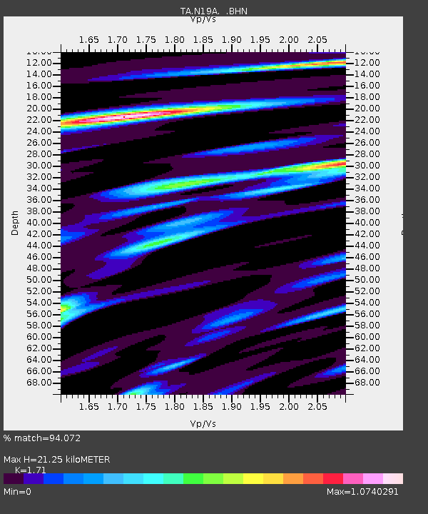
| Estimated Moho Depth: |
21.25 km |
| Estimated Crust Vp/Vs: |
1.71 |
| Assumed Crust Vp: |
6.207 km/s |
| Estimated Crust Vs: |
3.63 km/s |
| Estimated Crust Poisson's Ratio: |
0.24 |
|
| Radial Match: |
94.072 % |
| Radial Bump: |
400 |
| Transverse Match: |
79.657005 % |
| Transverse Bump: |
400 |
| SOD ConfigId: |
2504 |
| Insert Time: |
2010-03-06 17:09:00.763 +0000 |
| GWidth: |
2.5 |
| Max Bumps: |
400 |
| Tol: |
0.001 |
|

Signal To Noise
| Channel | StoN | STA | LTA |
| TA:N19A: :BHN:20080416T06:02:25.24899Z | 4.213738 | 6.510836E-7 | 1.545145E-7 |
| TA:N19A: :BHE:20080416T06:02:25.24899Z | 2.1865153 | 3.2800608E-7 | 1.5001316E-7 |
| TA:N19A: :BHZ:20080416T06:02:25.24899Z | 4.6495733 | 2.8043075E-7 | 6.031322E-8 |
| Arrivals |
| Ps | 2.6 SECOND |
| PpPs | 8.7 SECOND |
| PsPs/PpSs | 11 SECOND |


