You are here: Home > Network List > TJ - Tajikistan National Seismic Network Stations List
> Station CHRDR Chorukh Dayron, Tajikistan > Earthquake Result Viewer
CHRDR Chorukh Dayron, Tajikistan - Earthquake Result Viewer
| Earthquake location: |
Hokkaido, Japan Region |
| Earthquake latitude/longitude: |
44.5/145.4 |
| Earthquake time(UTC): |
2018/10/26 (299) 03:04:53 GMT |
| Earthquake Depth: |
10 km |
| Earthquake Magnitude: |
5.6 Mww |
| Earthquake Catalog/Contributor: |
NEIC PDE/us |
|
| Network: |
TJ Tajikistan National Seismic Network |
| Station: |
CHRDR Chorukh Dayron, Tajikistan |
| Lat/Lon: |
40.39 N/69.67 E |
| Elevation: |
580 m |
|
| Distance: |
54.1 deg |
| Az: |
294.024 deg |
| Baz: |
58.776 deg |
| Ray Param: |
0.06563286 |
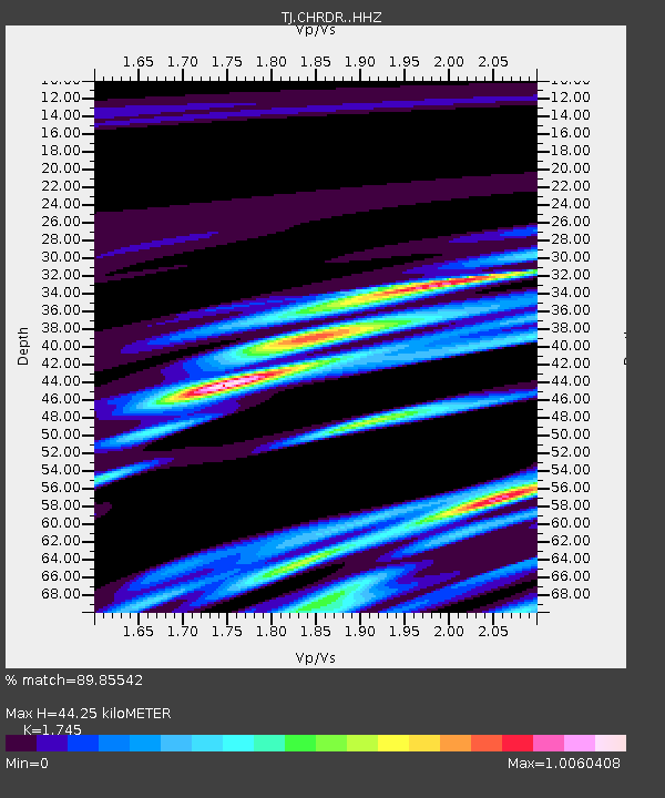
| Estimated Moho Depth: |
44.25 km |
| Estimated Crust Vp/Vs: |
1.75 |
| Assumed Crust Vp: |
6.316 km/s |
| Estimated Crust Vs: |
3.619 km/s |
| Estimated Crust Poisson's Ratio: |
0.26 |
|
| Radial Match: |
89.85542 % |
| Radial Bump: |
400 |
| Transverse Match: |
81.4395 % |
| Transverse Bump: |
400 |
| SOD ConfigId: |
13570011 |
| Insert Time: |
2019-05-01 15:09:04.232 +0000 |
| GWidth: |
2.5 |
| Max Bumps: |
400 |
| Tol: |
0.001 |
|

Signal To Noise
| Channel | StoN | STA | LTA |
| TJ:CHRDR: :HHZ:20181026T03:13:47.859973Z | 12.709839 | 1.2007478E-6 | 9.447388E-8 |
| TJ:CHRDR: :HHN:20181026T03:13:47.859973Z | 2.6591961 | 2.8792982E-7 | 1.08277014E-7 |
| TJ:CHRDR: :HHE:20181026T03:13:47.859973Z | 4.457968 | 4.225702E-7 | 9.478986E-8 |
| Arrivals |
| Ps | 5.5 SECOND |
| PpPs | 18 SECOND |
| PsPs/PpSs | 24 SECOND |


