You are here: Home > Network List > TJ - Tajikistan National Seismic Network Stations List
> Station GARM Garm, Tajikistan > Earthquake Result Viewer
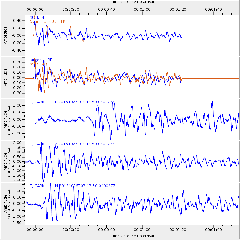
GARM Garm, Tajikistan - Earthquake Result Viewer
*The percent match for this event was below the threshold and hence no stack was calculated.
| Earthquake location: |
Hokkaido, Japan Region |
| Earthquake latitude/longitude: |
44.5/145.4 |
| Earthquake time(UTC): |
2018/10/26 (299) 03:04:53 GMT |
| Earthquake Depth: |
10 km |
| Earthquake Magnitude: |
5.6 Mww |
| Earthquake Catalog/Contributor: |
NEIC PDE/us |
|
| Network: |
TJ Tajikistan National Seismic Network |
| Station: |
GARM Garm, Tajikistan |
| Lat/Lon: |
39.00 N/70.32 E |
| Elevation: |
1305 m |
|
| Distance: |
54.4 deg |
| Az: |
292.25 deg |
| Baz: |
58.151 deg |
| Ray Param: |
$rayparam |
*The percent match for this event was below the threshold and hence was not used in the summary stack. |
|
| Radial Match: |
77.62608 % |
| Radial Bump: |
400 |
| Transverse Match: |
78.70319 % |
| Transverse Bump: |
400 |
| SOD ConfigId: |
13570011 |
| Insert Time: |
2019-05-01 15:09:04.463 +0000 |
| GWidth: |
2.5 |
| Max Bumps: |
400 |
| Tol: |
0.001 |
|
Signal To Noise
| Channel | StoN | STA | LTA |
| TJ:GARM: :HHZ:20181026T03:13:50.040027Z | 6.748846 | 9.663484E-7 | 1.431872E-7 |
| TJ:GARM: :HHN:20181026T03:13:50.040027Z | 1.3627037 | 1.4507835E-7 | 1.0646361E-7 |
| TJ:GARM: :HHE:20181026T03:13:50.040027Z | 4.1733165 | 4.7518637E-7 | 1.1386301E-7 |
| Arrivals |
| Ps | |
| PpPs | |
| PsPs/PpSs | |


