You are here: Home > Network List > TA - USArray Transportable Network (new EarthScope stations) Stations List
> Station N19A John Jarvie Ranch (BLM), Flaming Gorge, UT, USA > Earthquake Result Viewer
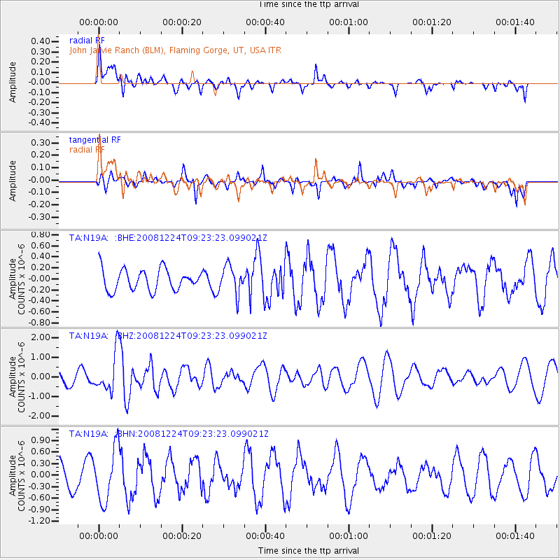
N19A John Jarvie Ranch (BLM), Flaming Gorge, UT, USA - Earthquake Result Viewer
*The percent match for this event was below the threshold and hence no stack was calculated.
| Earthquake location: |
Tonga Islands Region |
| Earthquake latitude/longitude: |
-17.3/-171.9 |
| Earthquake time(UTC): |
2008/12/24 (359) 09:11:34 GMT |
| Earthquake Depth: |
9.0 km |
| Earthquake Magnitude: |
5.9 MB, 5.6 MS, 6.0 MW, 6.0 MW |
| Earthquake Catalog/Contributor: |
WHDF/NEIC |
|
| Network: |
TA USArray Transportable Network (new EarthScope stations) |
| Station: |
N19A John Jarvie Ranch (BLM), Flaming Gorge, UT, USA |
| Lat/Lon: |
40.89 N/109.18 W |
| Elevation: |
1703 m |
|
| Distance: |
82.0 deg |
| Az: |
42.881 deg |
| Baz: |
239.043 deg |
| Ray Param: |
$rayparam |
*The percent match for this event was below the threshold and hence was not used in the summary stack. |
|
| Radial Match: |
52.495228 % |
| Radial Bump: |
400 |
| Transverse Match: |
35.870792 % |
| Transverse Bump: |
298 |
| SOD ConfigId: |
2658 |
| Insert Time: |
2010-03-06 17:10:15.934 +0000 |
| GWidth: |
2.5 |
| Max Bumps: |
400 |
| Tol: |
0.001 |
|
Signal To Noise
| Channel | StoN | STA | LTA |
| TA:N19A: :BHZ:20081224T09:23:23.099021Z | 4.695238 | 1.0351082E-6 | 2.2045916E-7 |
| TA:N19A: :BHN:20081224T09:23:23.099021Z | 1.9220066 | 7.117114E-7 | 3.70296E-7 |
| TA:N19A: :BHE:20081224T09:23:23.099021Z | 1.3479347 | 2.5644056E-7 | 1.9024701E-7 |
| Arrivals |
| Ps | |
| PpPs | |
| PsPs/PpSs | |


