You are here: Home > Network List > AK - Alaska Regional Network Stations List
> Station GAMB Gambell Broadband > Earthquake Result Viewer
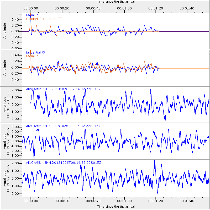
GAMB Gambell Broadband - Earthquake Result Viewer
*The percent match for this event was below the threshold and hence no stack was calculated.
| Earthquake location: |
Mariana Islands Region |
| Earthquake latitude/longitude: |
17.4/147.9 |
| Earthquake time(UTC): |
2018/10/26 (299) 09:05:39 GMT |
| Earthquake Depth: |
10 km |
| Earthquake Magnitude: |
5.7 mww |
| Earthquake Catalog/Contributor: |
NEIC PDE/us |
|
| Network: |
AK Alaska Regional Network |
| Station: |
GAMB Gambell Broadband |
| Lat/Lon: |
63.78 N/171.70 W |
| Elevation: |
10 m |
|
| Distance: |
53.9 deg |
| Az: |
20.881 deg |
| Baz: |
230.009 deg |
| Ray Param: |
$rayparam |
*The percent match for this event was below the threshold and hence was not used in the summary stack. |
|
| Radial Match: |
58.820206 % |
| Radial Bump: |
400 |
| Transverse Match: |
57.73472 % |
| Transverse Bump: |
400 |
| SOD ConfigId: |
13570011 |
| Insert Time: |
2019-05-01 15:11:43.077 +0000 |
| GWidth: |
2.5 |
| Max Bumps: |
400 |
| Tol: |
0.001 |
|
Signal To Noise
| Channel | StoN | STA | LTA |
| AK:GAMB: :BHZ:20181026T09:14:32.228015Z | 3.0334907 | 1.7964079E-6 | 5.9219167E-7 |
| AK:GAMB: :BHN:20181026T09:14:32.228015Z | 1.4813923 | 8.168678E-7 | 5.5141896E-7 |
| AK:GAMB: :BHE:20181026T09:14:32.228015Z | 0.9079434 | 8.4763235E-7 | 9.33574E-7 |
| Arrivals |
| Ps | |
| PpPs | |
| PsPs/PpSs | |


