You are here: Home > Network List > TA - USArray Transportable Network (new EarthScope stations) Stations List
> Station N19A John Jarvie Ranch (BLM), Flaming Gorge, UT, USA > Earthquake Result Viewer
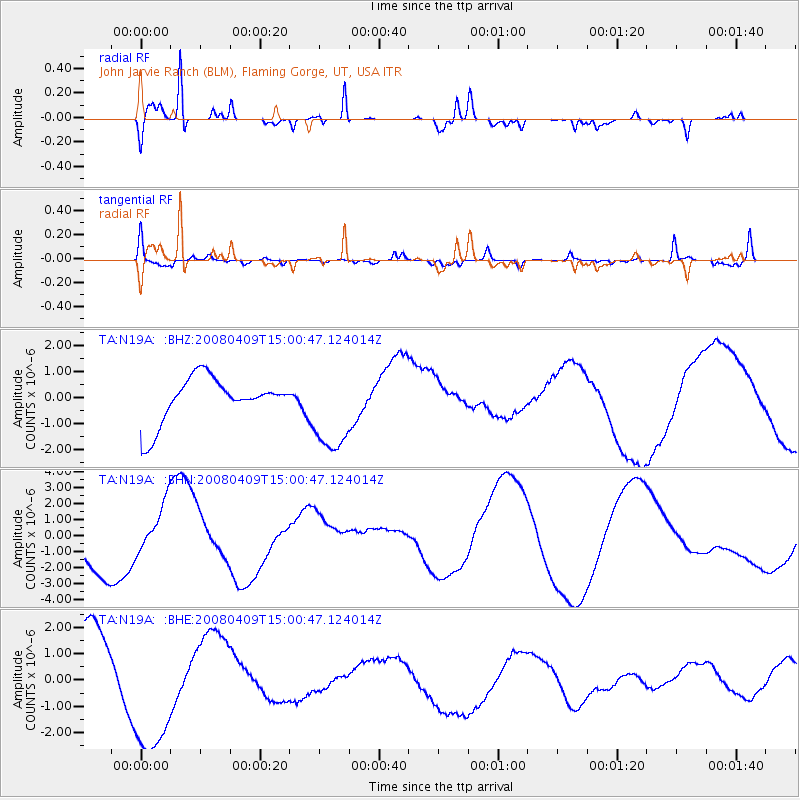
N19A John Jarvie Ranch (BLM), Flaming Gorge, UT, USA - Earthquake Result Viewer
*The percent match for this event was below the threshold and hence no stack was calculated.
| Earthquake location: |
Vanuatu Islands |
| Earthquake latitude/longitude: |
-20.0/168.9 |
| Earthquake time(UTC): |
2008/04/09 (100) 14:47:50 GMT |
| Earthquake Depth: |
35 km |
| Earthquake Magnitude: |
5.9 MB, 6.2 MS, 6.3 MW |
| Earthquake Catalog/Contributor: |
WHDF/NEIC |
|
| Network: |
TA USArray Transportable Network (new EarthScope stations) |
| Station: |
N19A John Jarvie Ranch (BLM), Flaming Gorge, UT, USA |
| Lat/Lon: |
40.89 N/109.18 W |
| Elevation: |
1703 m |
|
| Distance: |
97.0 deg |
| Az: |
49.136 deg |
| Baz: |
249.746 deg |
| Ray Param: |
$rayparam |
*The percent match for this event was below the threshold and hence was not used in the summary stack. |
|
| Radial Match: |
85.24529 % |
| Radial Bump: |
300 |
| Transverse Match: |
27.054659 % |
| Transverse Bump: |
349 |
| SOD ConfigId: |
2504 |
| Insert Time: |
2010-03-06 17:10:22.796 +0000 |
| GWidth: |
2.5 |
| Max Bumps: |
400 |
| Tol: |
0.001 |
|
Signal To Noise
| Channel | StoN | STA | LTA |
| TA:N19A: :BHN:20080409T15:00:47.124014Z | 0.9872889 | 1.4579108E-6 | 1.4766811E-6 |
| TA:N19A: :BHE:20080409T15:00:47.124014Z | 2.043973 | 2.540846E-6 | 1.2430918E-6 |
| TA:N19A: :BHZ:20080409T15:00:47.124014Z | 1.9630877 | 1.7029232E-6 | 8.674718E-7 |
| Arrivals |
| Ps | |
| PpPs | |
| PsPs/PpSs | |


