You are here: Home > Network List > AV - Alaska Volcano Observatory Stations List
> Station PLBL Mt. Peulik Volcano, Alaska > Earthquake Result Viewer
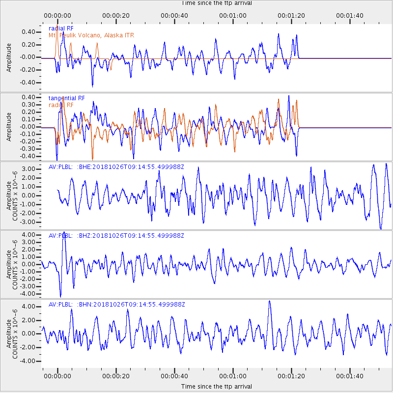
PLBL Mt. Peulik Volcano, Alaska - Earthquake Result Viewer
*The percent match for this event was below the threshold and hence no stack was calculated.
| Earthquake location: |
Mariana Islands Region |
| Earthquake latitude/longitude: |
17.4/147.9 |
| Earthquake time(UTC): |
2018/10/26 (299) 09:05:39 GMT |
| Earthquake Depth: |
10 km |
| Earthquake Magnitude: |
5.7 mww |
| Earthquake Catalog/Contributor: |
NEIC PDE/us |
|
| Network: |
AV Alaska Volcano Observatory |
| Station: |
PLBL Mt. Peulik Volcano, Alaska |
| Lat/Lon: |
57.70 N/156.82 W |
| Elevation: |
461 m |
|
| Distance: |
57.2 deg |
| Az: |
31.696 deg |
| Baz: |
249.139 deg |
| Ray Param: |
$rayparam |
*The percent match for this event was below the threshold and hence was not used in the summary stack. |
|
| Radial Match: |
58.877193 % |
| Radial Bump: |
400 |
| Transverse Match: |
55.40998 % |
| Transverse Bump: |
400 |
| SOD ConfigId: |
13570011 |
| Insert Time: |
2019-05-01 15:12:59.034 +0000 |
| GWidth: |
2.5 |
| Max Bumps: |
400 |
| Tol: |
0.001 |
|
Signal To Noise
| Channel | StoN | STA | LTA |
| AV:PLBL: :BHZ:20181026T09:14:55.499988Z | 3.4079788 | 2.2246725E-6 | 6.5278357E-7 |
| AV:PLBL: :BHN:20181026T09:14:55.499988Z | 1.0780708 | 1.2642768E-6 | 1.1727215E-6 |
| AV:PLBL: :BHE:20181026T09:14:55.499988Z | 1.5734797 | 1.4367841E-6 | 9.1312535E-7 |
| Arrivals |
| Ps | |
| PpPs | |
| PsPs/PpSs | |


