You are here: Home > Network List > AV - Alaska Volcano Observatory Stations List
> Station SPCR Ckakachatna River, Mount Spurr, Alaska > Earthquake Result Viewer
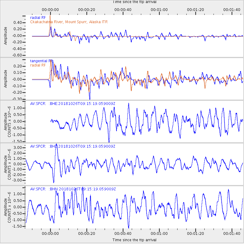
SPCR Ckakachatna River, Mount Spurr, Alaska - Earthquake Result Viewer
*The percent match for this event was below the threshold and hence no stack was calculated.
| Earthquake location: |
Mariana Islands Region |
| Earthquake latitude/longitude: |
17.4/147.9 |
| Earthquake time(UTC): |
2018/10/26 (299) 09:05:39 GMT |
| Earthquake Depth: |
10 km |
| Earthquake Magnitude: |
5.7 mww |
| Earthquake Catalog/Contributor: |
NEIC PDE/us |
|
| Network: |
AV Alaska Volcano Observatory |
| Station: |
SPCR Ckakachatna River, Mount Spurr, Alaska |
| Lat/Lon: |
61.20 N/152.21 W |
| Elevation: |
984 m |
|
| Distance: |
60.6 deg |
| Az: |
28.759 deg |
| Baz: |
251.587 deg |
| Ray Param: |
$rayparam |
*The percent match for this event was below the threshold and hence was not used in the summary stack. |
|
| Radial Match: |
70.44278 % |
| Radial Bump: |
400 |
| Transverse Match: |
62.93609 % |
| Transverse Bump: |
400 |
| SOD ConfigId: |
13570011 |
| Insert Time: |
2019-05-01 15:13:10.027 +0000 |
| GWidth: |
2.5 |
| Max Bumps: |
400 |
| Tol: |
0.001 |
|
Signal To Noise
| Channel | StoN | STA | LTA |
| AV:SPCR: :BHZ:20181026T09:15:19.059009Z | 3.5889294 | 2.0137754E-6 | 5.611076E-7 |
| AV:SPCR: :BHN:20181026T09:15:19.059009Z | 1.7108521 | 8.716718E-7 | 5.094957E-7 |
| AV:SPCR: :BHE:20181026T09:15:19.059009Z | 2.3459237 | 7.898173E-7 | 3.3667646E-7 |
| Arrivals |
| Ps | |
| PpPs | |
| PsPs/PpSs | |


