You are here: Home > Network List > CI - Caltech Regional Seismic Network Stations List
> Station SMM Simmler, CA, USA > Earthquake Result Viewer
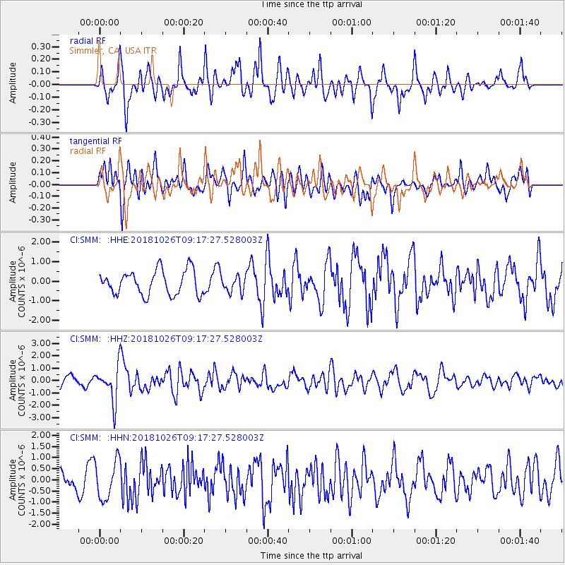
SMM Simmler, CA, USA - Earthquake Result Viewer
*The percent match for this event was below the threshold and hence no stack was calculated.
| Earthquake location: |
Mariana Islands Region |
| Earthquake latitude/longitude: |
17.4/147.9 |
| Earthquake time(UTC): |
2018/10/26 (299) 09:05:39 GMT |
| Earthquake Depth: |
10 km |
| Earthquake Magnitude: |
5.7 mww |
| Earthquake Catalog/Contributor: |
NEIC PDE/us |
|
| Network: |
CI Caltech Regional Seismic Network |
| Station: |
SMM Simmler, CA, USA |
| Lat/Lon: |
35.31 N/120.00 W |
| Elevation: |
599 m |
|
| Distance: |
81.8 deg |
| Az: |
55.65 deg |
| Baz: |
285.418 deg |
| Ray Param: |
$rayparam |
*The percent match for this event was below the threshold and hence was not used in the summary stack. |
|
| Radial Match: |
71.352165 % |
| Radial Bump: |
400 |
| Transverse Match: |
71.81126 % |
| Transverse Bump: |
400 |
| SOD ConfigId: |
13570011 |
| Insert Time: |
2019-05-01 15:14:45.248 +0000 |
| GWidth: |
2.5 |
| Max Bumps: |
400 |
| Tol: |
0.001 |
|
Signal To Noise
| Channel | StoN | STA | LTA |
| CI:SMM: :HHZ:20181026T09:17:27.528003Z | 4.1135883 | 1.4573161E-6 | 3.542688E-7 |
| CI:SMM: :HHN:20181026T09:17:27.528003Z | 2.797417 | 8.6361445E-7 | 3.087185E-7 |
| CI:SMM: :HHE:20181026T09:17:27.528003Z | 0.65716 | 4.0885706E-7 | 6.2215753E-7 |
| Arrivals |
| Ps | |
| PpPs | |
| PsPs/PpSs | |


