You are here: Home > Network List > CN - Canadian National Seismograph Network Stations List
> Station INK INUVIK, NT > Earthquake Result Viewer
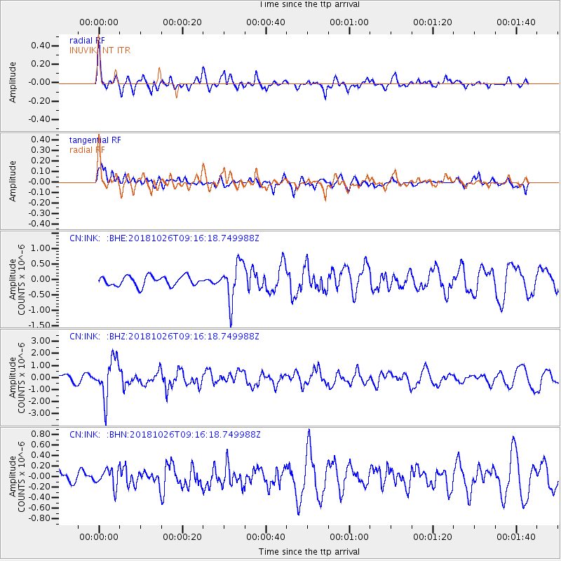
INK INUVIK, NT - Earthquake Result Viewer
*The percent match for this event was below the threshold and hence no stack was calculated.
| Earthquake location: |
Mariana Islands Region |
| Earthquake latitude/longitude: |
17.4/147.9 |
| Earthquake time(UTC): |
2018/10/26 (299) 09:05:39 GMT |
| Earthquake Depth: |
10 km |
| Earthquake Magnitude: |
5.7 mww |
| Earthquake Catalog/Contributor: |
NEIC PDE/us |
|
| Network: |
CN Canadian National Seismograph Network |
| Station: |
INK INUVIK, NT |
| Lat/Lon: |
68.31 N/133.53 W |
| Elevation: |
44 m |
|
| Distance: |
69.8 deg |
| Az: |
22.856 deg |
| Baz: |
266.035 deg |
| Ray Param: |
$rayparam |
*The percent match for this event was below the threshold and hence was not used in the summary stack. |
|
| Radial Match: |
75.78145 % |
| Radial Bump: |
400 |
| Transverse Match: |
64.33675 % |
| Transverse Bump: |
400 |
| SOD ConfigId: |
13570011 |
| Insert Time: |
2019-05-01 15:15:05.284 +0000 |
| GWidth: |
2.5 |
| Max Bumps: |
400 |
| Tol: |
0.001 |
|
Signal To Noise
| Channel | StoN | STA | LTA |
| CN:INK: :BHZ:20181026T09:16:18.749988Z | 5.9379983 | 1.6371138E-6 | 2.757013E-7 |
| CN:INK: :BHN:20181026T09:16:18.749988Z | 0.8134845 | 1.7643107E-7 | 2.1688314E-7 |
| CN:INK: :BHE:20181026T09:16:18.749988Z | 4.0197234 | 6.3081694E-7 | 1.5693043E-7 |
| Arrivals |
| Ps | |
| PpPs | |
| PsPs/PpSs | |


