You are here: Home > Network List > MM - Myanmar National Seismic Network Stations List
> Station NGU Ngaung U, Myanmar > Earthquake Result Viewer
NGU Ngaung U, Myanmar - Earthquake Result Viewer
| Earthquake location: |
Mariana Islands Region |
| Earthquake latitude/longitude: |
17.4/147.9 |
| Earthquake time(UTC): |
2018/10/26 (299) 09:05:39 GMT |
| Earthquake Depth: |
10 km |
| Earthquake Magnitude: |
5.7 mww |
| Earthquake Catalog/Contributor: |
NEIC PDE/us |
|
| Network: |
MM Myanmar National Seismic Network |
| Station: |
NGU Ngaung U, Myanmar |
| Lat/Lon: |
21.21 N/94.92 E |
| Elevation: |
70 m |
|
| Distance: |
49.9 deg |
| Az: |
283.335 deg |
| Baz: |
84.742 deg |
| Ray Param: |
0.0683766 |
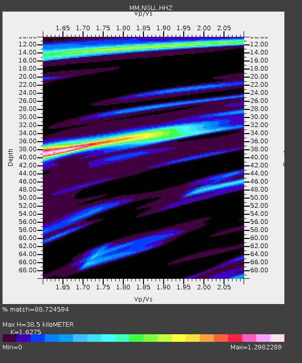
| Estimated Moho Depth: |
38.5 km |
| Estimated Crust Vp/Vs: |
1.63 |
| Assumed Crust Vp: |
6.036 km/s |
| Estimated Crust Vs: |
3.709 km/s |
| Estimated Crust Poisson's Ratio: |
0.20 |
|
| Radial Match: |
88.724594 % |
| Radial Bump: |
358 |
| Transverse Match: |
76.29733 % |
| Transverse Bump: |
302 |
| SOD ConfigId: |
13570011 |
| Insert Time: |
2019-05-01 15:16:26.144 +0000 |
| GWidth: |
2.5 |
| Max Bumps: |
400 |
| Tol: |
0.001 |
|

Signal To Noise
| Channel | StoN | STA | LTA |
| MM:NGU: :HHZ:20181026T09:14:02.680011Z | 24.788166 | 4.674878E-6 | 1.8859313E-7 |
| MM:NGU: :HHN:20181026T09:14:02.680011Z | 2.2090645 | 3.831862E-7 | 1.7346085E-7 |
| MM:NGU: :HHE:20181026T09:14:02.680011Z | 4.3740993 | 8.487406E-7 | 1.9403781E-7 |
| Arrivals |
| Ps | 4.2 SECOND |
| PpPs | 16 SECOND |
| PsPs/PpSs | 20 SECOND |


