You are here: Home > Network List > TA - USArray Transportable Network (new EarthScope stations) Stations List
> Station G16A Moss Hill, Ennis, MT, USA > Earthquake Result Viewer
G16A Moss Hill, Ennis, MT, USA - Earthquake Result Viewer
| Earthquake location: |
Costa Rica |
| Earthquake latitude/longitude: |
10.2/-84.2 |
| Earthquake time(UTC): |
2009/01/08 (008) 19:21:35 GMT |
| Earthquake Depth: |
14 km |
| Earthquake Magnitude: |
5.7 MB, 6.0 MS, 6.1 MW, 6.1 MW |
| Earthquake Catalog/Contributor: |
WHDF/NEIC |
|
| Network: |
TA USArray Transportable Network (new EarthScope stations) |
| Station: |
G16A Moss Hill, Ennis, MT, USA |
| Lat/Lon: |
45.23 N/111.80 W |
| Elevation: |
1769 m |
|
| Distance: |
42.2 deg |
| Az: |
330.835 deg |
| Baz: |
137.24 deg |
| Ray Param: |
0.07328989 |
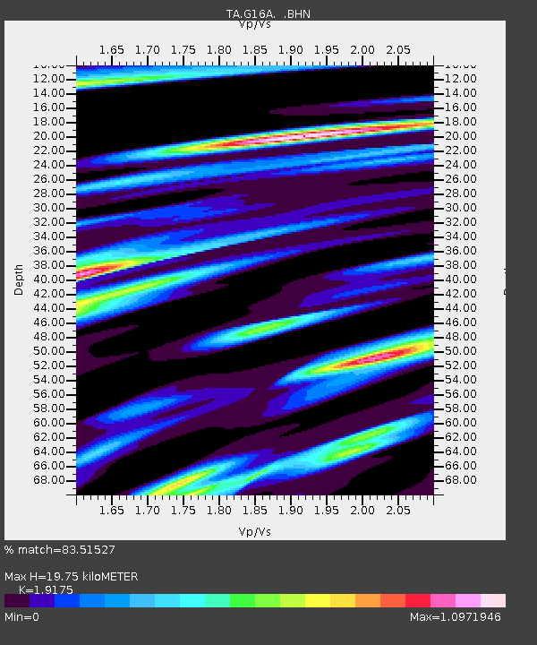
| Estimated Moho Depth: |
19.75 km |
| Estimated Crust Vp/Vs: |
1.92 |
| Assumed Crust Vp: |
6.35 km/s |
| Estimated Crust Vs: |
3.312 km/s |
| Estimated Crust Poisson's Ratio: |
0.31 |
|
| Radial Match: |
83.51527 % |
| Radial Bump: |
340 |
| Transverse Match: |
58.117744 % |
| Transverse Bump: |
400 |
| SOD ConfigId: |
2834 |
| Insert Time: |
2010-03-06 17:11:26.139 +0000 |
| GWidth: |
2.5 |
| Max Bumps: |
400 |
| Tol: |
0.001 |
|

Signal To Noise
| Channel | StoN | STA | LTA |
| TA:G16A: :BHN:20090108T19:28:57.198989Z | 3.3538067 | 5.0216767E-7 | 1.4973065E-7 |
| TA:G16A: :BHE:20090108T19:28:57.198989Z | 0.77145875 | 1.2495927E-7 | 1.6197791E-7 |
| TA:G16A: :BHZ:20090108T19:28:57.198989Z | 0.57556444 | 1.085846E-7 | 1.886576E-7 |
| Arrivals |
| Ps | 3.0 SECOND |
| PpPs | 8.5 SECOND |
| PsPs/PpSs | 12 SECOND |


