You are here: Home > Network List > TA - USArray Transportable Network (new EarthScope stations) Stations List
> Station E23K Chandalar, AK, USA > Earthquake Result Viewer
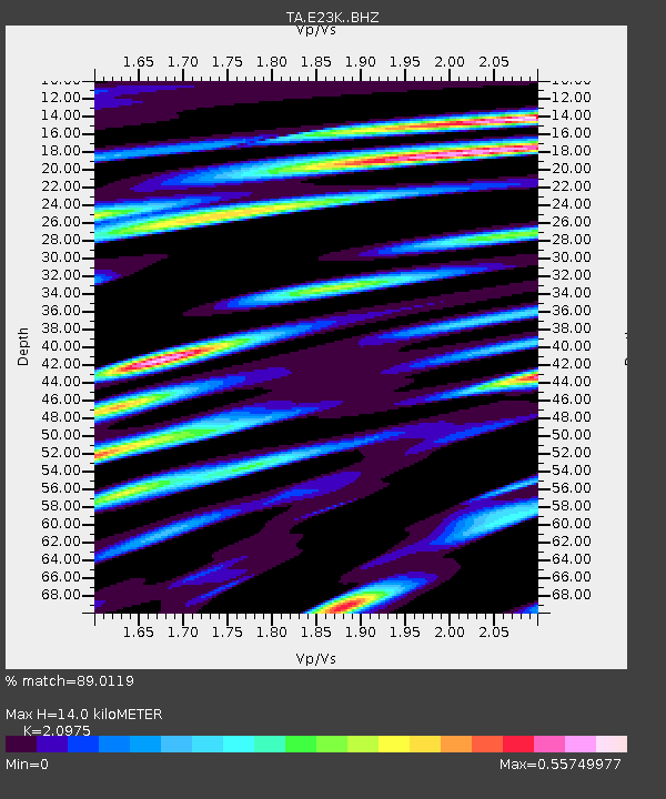
E23K Chandalar, AK, USA - Earthquake Result Viewer
| Earthquake location: |
Mariana Islands Region |
| Earthquake latitude/longitude: |
17.4/147.9 |
| Earthquake time(UTC): |
2018/10/26 (299) 09:05:39 GMT |
| Earthquake Depth: |
10 km |
| Earthquake Magnitude: |
5.7 mww |
| Earthquake Catalog/Contributor: |
NEIC PDE/us |
|
| Network: |
TA USArray Transportable Network (new EarthScope stations) |
| Station: |
E23K Chandalar, AK, USA |
| Lat/Lon: |
68.06 N/149.62 W |
| Elevation: |
1084 m |
|
| Distance: |
63.8 deg |
| Az: |
21.802 deg |
| Baz: |
250.682 deg |
| Ray Param: |
0.059309896 |
| Estimated Moho Depth: |
14.0 km |
| Estimated Crust Vp/Vs: |
2.10 |
| Assumed Crust Vp: |
6.316 km/s |
| Estimated Crust Vs: |
3.011 km/s |
| Estimated Crust Poisson's Ratio: |
0.35 |
|
| Radial Match: |
89.0119 % |
| Radial Bump: |
400 |
| Transverse Match: |
82.908035 % |
| Transverse Bump: |
400 |
| SOD ConfigId: |
13570011 |
| Insert Time: |
2019-05-01 15:18:43.384 +0000 |
| GWidth: |
2.5 |
| Max Bumps: |
400 |
| Tol: |
0.001 |
|

Signal To Noise
| Channel | StoN | STA | LTA |
| TA:E23K: :BHZ:20181026T09:15:41.075Z | 22.094389 | 2.5539227E-6 | 1.1559146E-7 |
| TA:E23K: :BHN:20181026T09:15:41.075Z | 4.3899426 | 4.8797267E-7 | 1.1115697E-7 |
| TA:E23K: :BHE:20181026T09:15:41.075Z | 4.8600063 | 8.646487E-7 | 1.7791102E-7 |
| Arrivals |
| Ps | 2.5 SECOND |
| PpPs | 6.6 SECOND |
| PsPs/PpSs | 9.1 SECOND |


