You are here: Home > Network List > TA - USArray Transportable Network (new EarthScope stations) Stations List
> Station F20K Avaraart Lake, AK, USA > Earthquake Result Viewer
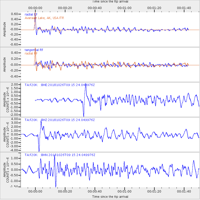
F20K Avaraart Lake, AK, USA - Earthquake Result Viewer
*The percent match for this event was below the threshold and hence no stack was calculated.
| Earthquake location: |
Mariana Islands Region |
| Earthquake latitude/longitude: |
17.4/147.9 |
| Earthquake time(UTC): |
2018/10/26 (299) 09:05:39 GMT |
| Earthquake Depth: |
10 km |
| Earthquake Magnitude: |
5.7 mww |
| Earthquake Catalog/Contributor: |
NEIC PDE/us |
|
| Network: |
TA USArray Transportable Network (new EarthScope stations) |
| Station: |
F20K Avaraart Lake, AK, USA |
| Lat/Lon: |
67.05 N/155.73 W |
| Elevation: |
136 m |
|
| Distance: |
61.3 deg |
| Az: |
21.865 deg |
| Baz: |
245.069 deg |
| Ray Param: |
$rayparam |
*The percent match for this event was below the threshold and hence was not used in the summary stack. |
|
| Radial Match: |
72.30614 % |
| Radial Bump: |
400 |
| Transverse Match: |
71.26812 % |
| Transverse Bump: |
400 |
| SOD ConfigId: |
13570011 |
| Insert Time: |
2019-05-01 15:18:52.387 +0000 |
| GWidth: |
2.5 |
| Max Bumps: |
400 |
| Tol: |
0.001 |
|
Signal To Noise
| Channel | StoN | STA | LTA |
| TA:F20K: :BHZ:20181026T09:15:24.049976Z | 8.653037 | 1.7788136E-6 | 2.0557101E-7 |
| TA:F20K: :BHN:20181026T09:15:24.049976Z | 2.7854722 | 3.9094087E-7 | 1.4034994E-7 |
| TA:F20K: :BHE:20181026T09:15:24.049976Z | 7.7028995 | 1.0063195E-6 | 1.3064165E-7 |
| Arrivals |
| Ps | |
| PpPs | |
| PsPs/PpSs | |


