You are here: Home > Network List > TA - USArray Transportable Network (new EarthScope stations) Stations List
> Station F26K Sheenjek River, AK, USA > Earthquake Result Viewer
F26K Sheenjek River, AK, USA - Earthquake Result Viewer

| Earthquake location: |
Mariana Islands Region |
| Earthquake latitude/longitude: |
17.4/147.9 |
| Earthquake time(UTC): |
2018/10/26 (299) 09:05:39 GMT |
| Earthquake Depth: |
10 km |
| Earthquake Magnitude: |
5.7 mww |
| Earthquake Catalog/Contributor: |
NEIC PDE/us |
|
| Network: |
TA USArray Transportable Network (new EarthScope stations) |
| Station: |
F26K Sheenjek River, AK, USA |
| Lat/Lon: |
67.69 N/144.15 W |
| Elevation: |
683 m |
|
| Distance: |
65.7 deg |
| Az: |
22.842 deg |
| Baz: |
256.189 deg |
| Ray Param: |
0.058081146 |
| Estimated Moho Depth: |
29.0 km |
| Estimated Crust Vp/Vs: |
1.90 |
| Assumed Crust Vp: |
6.522 km/s |
| Estimated Crust Vs: |
3.437 km/s |
| Estimated Crust Poisson's Ratio: |
0.31 |
|
| Radial Match: |
86.89282 % |
| Radial Bump: |
362 |
| Transverse Match: |
70.92219 % |
| Transverse Bump: |
400 |
| SOD ConfigId: |
13570011 |
| Insert Time: |
2019-05-01 15:18:54.112 +0000 |
| GWidth: |
2.5 |
| Max Bumps: |
400 |
| Tol: |
0.001 |
|
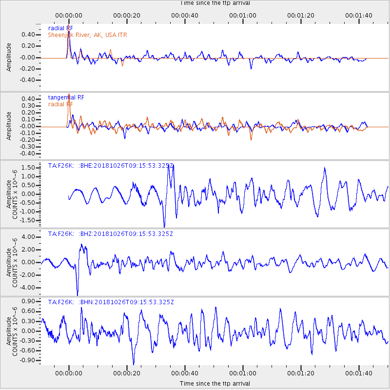
Signal To Noise
| Channel | StoN | STA | LTA |
| TA:F26K: :BHZ:20181026T09:15:53.325Z | 4.648607 | 1.948927E-6 | 4.1924972E-7 |
| TA:F26K: :BHN:20181026T09:15:53.325Z | 0.88909596 | 2.7626737E-7 | 3.107284E-7 |
| TA:F26K: :BHE:20181026T09:15:53.325Z | 2.7778587 | 8.439001E-7 | 3.037952E-7 |
| Arrivals |
| Ps | 4.2 SECOND |
| PpPs | 12 SECOND |
| PsPs/PpSs | 17 SECOND |


