You are here: Home > Network List > AU - Australian Seismological Centre Stations List
> Station PSA00 Pilbara Seismic Array Element A0 > Earthquake Result Viewer
PSA00 Pilbara Seismic Array Element A0 - Earthquake Result Viewer
| Earthquake location: |
Southeast Of Loyalty Islands |
| Earthquake latitude/longitude: |
-22.5/173.1 |
| Earthquake time(UTC): |
2016/08/12 (225) 01:26:35 GMT |
| Earthquake Depth: |
10 km |
| Earthquake Magnitude: |
7.2 MWW, 7.6 MI |
| Earthquake Catalog/Contributor: |
NEIC PDE/NEIC COMCAT |
|
| Network: |
AU Australian Seismological Centre |
| Station: |
PSA00 Pilbara Seismic Array Element A0 |
| Lat/Lon: |
21.57 S/119.85 E |
| Elevation: |
305 m |
|
| Distance: |
49.2 deg |
| Az: |
260.392 deg |
| Baz: |
101.582 deg |
| Ray Param: |
0.06887771 |
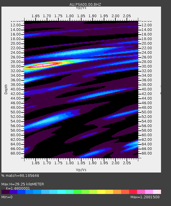
| Estimated Moho Depth: |
29.25 km |
| Estimated Crust Vp/Vs: |
1.68 |
| Assumed Crust Vp: |
6.464 km/s |
| Estimated Crust Vs: |
3.847 km/s |
| Estimated Crust Poisson's Ratio: |
0.23 |
|
| Radial Match: |
98.185646 % |
| Radial Bump: |
250 |
| Transverse Match: |
87.25093 % |
| Transverse Bump: |
400 |
| SOD ConfigId: |
1634031 |
| Insert Time: |
2016-08-26 01:26:43.029 +0000 |
| GWidth: |
2.5 |
| Max Bumps: |
400 |
| Tol: |
0.001 |
|

Signal To Noise
| Channel | StoN | STA | LTA |
| AU:PSA00:00:BHZ:20160812T01:34:52.143998Z | 23.37665 | 6.3361267E-6 | 2.710451E-7 |
| AU:PSA00:00:BH1:20160812T01:34:52.143998Z | 12.627314 | 3.776333E-6 | 2.9906067E-7 |
| AU:PSA00:00:BH2:20160812T01:34:52.143998Z | 4.4382076 | 8.618145E-7 | 1.9418076E-7 |
| Arrivals |
| Ps | 3.3 SECOND |
| PpPs | 11 SECOND |
| PsPs/PpSs | 15 SECOND |


