You are here: Home > Network List > TA - USArray Transportable Network (new EarthScope stations) Stations List
> Station G16A Moss Hill, Ennis, MT, USA > Earthquake Result Viewer
G16A Moss Hill, Ennis, MT, USA - Earthquake Result Viewer
| Earthquake location: |
Tonga Islands Region |
| Earthquake latitude/longitude: |
-23.0/-174.7 |
| Earthquake time(UTC): |
2009/03/19 (078) 18:17:40 GMT |
| Earthquake Depth: |
34 km |
| Earthquake Magnitude: |
7.0 MB, 7.6 MS, 7.6 MW, 7.6 MW |
| Earthquake Catalog/Contributor: |
WHDF/NEIC |
|
| Network: |
TA USArray Transportable Network (new EarthScope stations) |
| Station: |
G16A Moss Hill, Ennis, MT, USA |
| Lat/Lon: |
45.23 N/111.80 W |
| Elevation: |
1769 m |
|
| Distance: |
88.8 deg |
| Az: |
38.974 deg |
| Baz: |
235.071 deg |
| Ray Param: |
0.04229938 |
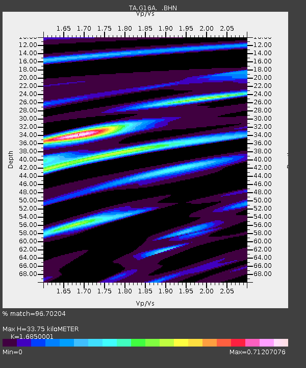
| Estimated Moho Depth: |
33.75 km |
| Estimated Crust Vp/Vs: |
1.69 |
| Assumed Crust Vp: |
6.35 km/s |
| Estimated Crust Vs: |
3.769 km/s |
| Estimated Crust Poisson's Ratio: |
0.23 |
|
| Radial Match: |
96.70204 % |
| Radial Bump: |
400 |
| Transverse Match: |
89.00804 % |
| Transverse Bump: |
400 |
| SOD ConfigId: |
2658 |
| Insert Time: |
2010-03-06 17:12:14.729 +0000 |
| GWidth: |
2.5 |
| Max Bumps: |
400 |
| Tol: |
0.001 |
|

Signal To Noise
| Channel | StoN | STA | LTA |
| TA:G16A: :BHN:20090319T18:29:59.899014Z | 18.212788 | 4.448879E-6 | 2.4427226E-7 |
| TA:G16A: :BHE:20090319T18:29:59.899014Z | 6.9995446 | 7.3999286E-7 | 1.0572014E-7 |
| TA:G16A: :BHZ:20090319T18:29:59.899014Z | 10.652441 | 1.2238389E-6 | 1.1488812E-7 |
| Arrivals |
| Ps | 3.7 SECOND |
| PpPs | 14 SECOND |
| PsPs/PpSs | 18 SECOND |


