You are here: Home > Network List > TA - USArray Transportable Network (new EarthScope stations) Stations List
> Station H16K Elim, AK, USA > Earthquake Result Viewer
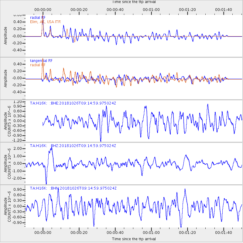
H16K Elim, AK, USA - Earthquake Result Viewer
*The percent match for this event was below the threshold and hence no stack was calculated.
| Earthquake location: |
Mariana Islands Region |
| Earthquake latitude/longitude: |
17.4/147.9 |
| Earthquake time(UTC): |
2018/10/26 (299) 09:05:39 GMT |
| Earthquake Depth: |
10 km |
| Earthquake Magnitude: |
5.7 mww |
| Earthquake Catalog/Contributor: |
NEIC PDE/us |
|
| Network: |
TA USArray Transportable Network (new EarthScope stations) |
| Station: |
H16K Elim, AK, USA |
| Lat/Lon: |
64.64 N/162.24 W |
| Elevation: |
216 m |
|
| Distance: |
57.8 deg |
| Az: |
22.908 deg |
| Baz: |
239.659 deg |
| Ray Param: |
$rayparam |
*The percent match for this event was below the threshold and hence was not used in the summary stack. |
|
| Radial Match: |
76.76381 % |
| Radial Bump: |
400 |
| Transverse Match: |
71.183945 % |
| Transverse Bump: |
400 |
| SOD ConfigId: |
13570011 |
| Insert Time: |
2019-05-01 15:19:07.890 +0000 |
| GWidth: |
2.5 |
| Max Bumps: |
400 |
| Tol: |
0.001 |
|
Signal To Noise
| Channel | StoN | STA | LTA |
| TA:H16K: :BHZ:20181026T09:14:59.975024Z | 6.13977 | 1.3296616E-6 | 2.1656538E-7 |
| TA:H16K: :BHN:20181026T09:14:59.975024Z | 3.0432065 | 4.5944395E-7 | 1.5097363E-7 |
| TA:H16K: :BHE:20181026T09:14:59.975024Z | 2.5469325 | 5.319559E-7 | 2.088614E-7 |
| Arrivals |
| Ps | |
| PpPs | |
| PsPs/PpSs | |


