You are here: Home > Network List > TA - USArray Transportable Network (new EarthScope stations) Stations List
> Station I30M Mount Dempster, Yukon, CAN > Earthquake Result Viewer
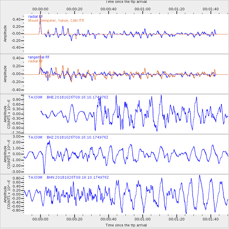
I30M Mount Dempster, Yukon, CAN - Earthquake Result Viewer
*The percent match for this event was below the threshold and hence no stack was calculated.
| Earthquake location: |
Mariana Islands Region |
| Earthquake latitude/longitude: |
17.4/147.9 |
| Earthquake time(UTC): |
2018/10/26 (299) 09:05:39 GMT |
| Earthquake Depth: |
10 km |
| Earthquake Magnitude: |
5.7 mww |
| Earthquake Catalog/Contributor: |
NEIC PDE/us |
|
| Network: |
TA USArray Transportable Network (new EarthScope stations) |
| Station: |
I30M Mount Dempster, Yukon, CAN |
| Lat/Lon: |
65.22 N/136.38 W |
| Elevation: |
1399 m |
|
| Distance: |
68.4 deg |
| Az: |
26.061 deg |
| Baz: |
264.562 deg |
| Ray Param: |
$rayparam |
*The percent match for this event was below the threshold and hence was not used in the summary stack. |
|
| Radial Match: |
61.740868 % |
| Radial Bump: |
400 |
| Transverse Match: |
74.13287 % |
| Transverse Bump: |
400 |
| SOD ConfigId: |
13570011 |
| Insert Time: |
2019-05-01 15:19:25.933 +0000 |
| GWidth: |
2.5 |
| Max Bumps: |
400 |
| Tol: |
0.001 |
|
Signal To Noise
| Channel | StoN | STA | LTA |
| TA:I30M: :BHZ:20181026T09:16:10.174976Z | 4.213808 | 1.4122787E-6 | 3.3515497E-7 |
| TA:I30M: :BHN:20181026T09:16:10.174976Z | 1.0713656 | 2.6940768E-7 | 2.5146193E-7 |
| TA:I30M: :BHE:20181026T09:16:10.174976Z | 2.1890793 | 5.231862E-7 | 2.389983E-7 |
| Arrivals |
| Ps | |
| PpPs | |
| PsPs/PpSs | |


