You are here: Home > Network List > TA - USArray Transportable Network (new EarthScope stations) Stations List
> Station P17K Kvichak River, AK, USA > Earthquake Result Viewer
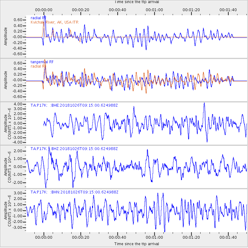
P17K Kvichak River, AK, USA - Earthquake Result Viewer
*The percent match for this event was below the threshold and hence no stack was calculated.
| Earthquake location: |
Mariana Islands Region |
| Earthquake latitude/longitude: |
17.4/147.9 |
| Earthquake time(UTC): |
2018/10/26 (299) 09:05:39 GMT |
| Earthquake Depth: |
10 km |
| Earthquake Magnitude: |
5.7 mww |
| Earthquake Catalog/Contributor: |
NEIC PDE/us |
|
| Network: |
TA USArray Transportable Network (new EarthScope stations) |
| Station: |
P17K Kvichak River, AK, USA |
| Lat/Lon: |
59.20 N/156.44 W |
| Elevation: |
91 m |
|
| Distance: |
57.9 deg |
| Az: |
30.123 deg |
| Baz: |
248.619 deg |
| Ray Param: |
$rayparam |
*The percent match for this event was below the threshold and hence was not used in the summary stack. |
|
| Radial Match: |
65.120544 % |
| Radial Bump: |
400 |
| Transverse Match: |
57.30658 % |
| Transverse Bump: |
400 |
| SOD ConfigId: |
13570011 |
| Insert Time: |
2019-05-01 15:20:18.078 +0000 |
| GWidth: |
2.5 |
| Max Bumps: |
400 |
| Tol: |
0.001 |
|
Signal To Noise
| Channel | StoN | STA | LTA |
| TA:P17K: :BHZ:20181026T09:15:00.624988Z | 2.6519077 | 1.5384289E-6 | 5.801216E-7 |
| TA:P17K: :BHN:20181026T09:15:00.624988Z | 1.2313501 | 1.0794995E-6 | 8.766797E-7 |
| TA:P17K: :BHE:20181026T09:15:00.624988Z | 1.7272173 | 1.8173861E-6 | 1.0522047E-6 |
| Arrivals |
| Ps | |
| PpPs | |
| PsPs/PpSs | |


