You are here: Home > Network List > TS - TERRAscope (Southern California Seismic Network) Stations List
> Station BAR Barrett Dam, California, USA > Earthquake Result Viewer
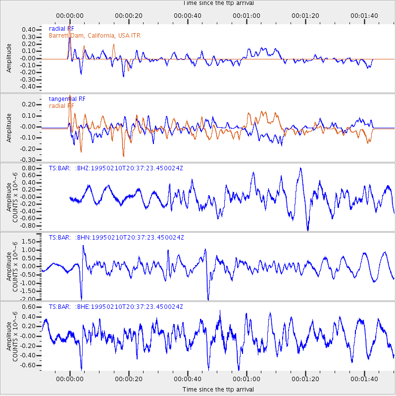
BAR Barrett Dam, California, USA - Earthquake Result Viewer
*The percent match for this event was below the threshold and hence no stack was calculated.
| Earthquake location: |
Chile-Bolivia Border Region |
| Earthquake latitude/longitude: |
-19.8/-68.5 |
| Earthquake time(UTC): |
1995/02/10 (041) 20:27:03 GMT |
| Earthquake Depth: |
164 km |
| Earthquake Magnitude: |
5.7 UNKNOWN, 5.4 MB, 5.7 MW |
| Earthquake Catalog/Contributor: |
WHDF/NEIC |
|
| Network: |
TS TERRAscope (Southern California Seismic Network) |
| Station: |
BAR Barrett Dam, California, USA |
| Lat/Lon: |
32.68 N/116.67 W |
| Elevation: |
548 m |
|
| Distance: |
69.5 deg |
| Az: |
317.915 deg |
| Baz: |
131.542 deg |
| Ray Param: |
$rayparam |
*The percent match for this event was below the threshold and hence was not used in the summary stack. |
|
| Radial Match: |
42.663227 % |
| Radial Bump: |
400 |
| Transverse Match: |
52.733635 % |
| Transverse Bump: |
400 |
| SOD ConfigId: |
4480 |
| Insert Time: |
2010-02-26 13:59:37.551 +0000 |
| GWidth: |
2.5 |
| Max Bumps: |
400 |
| Tol: |
0.001 |
|
Signal To Noise
| Channel | StoN | STA | LTA |
| TS:BAR: :BHN:19950210T20:37:23.450024Z | 3.5684454 | 6.648219E-7 | 1.8630575E-7 |
| TS:BAR: :BHE:19950210T20:37:23.450024Z | 1.225812 | 2.1718765E-7 | 1.7717859E-7 |
| TS:BAR: :BHZ:19950210T20:37:23.450024Z | 1.4898015 | 2.1650261E-7 | 1.4532313E-7 |
| Arrivals |
| Ps | |
| PpPs | |
| PsPs/PpSs | |


