You are here: Home > Network List > UW - Pacific Northwest Regional Seismic Network Stations List
> Station UMAT Pilot Rock, OR, USA > Earthquake Result Viewer
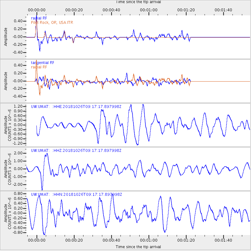
UMAT Pilot Rock, OR, USA - Earthquake Result Viewer
*The percent match for this event was below the threshold and hence no stack was calculated.
| Earthquake location: |
Mariana Islands Region |
| Earthquake latitude/longitude: |
17.4/147.9 |
| Earthquake time(UTC): |
2018/10/26 (299) 09:05:39 GMT |
| Earthquake Depth: |
10 km |
| Earthquake Magnitude: |
5.7 mww |
| Earthquake Catalog/Contributor: |
NEIC PDE/us |
|
| Network: |
UW Pacific Northwest Regional Seismic Network |
| Station: |
UMAT Pilot Rock, OR, USA |
| Lat/Lon: |
45.29 N/118.96 W |
| Elevation: |
1318 m |
|
| Distance: |
80.0 deg |
| Az: |
45.694 deg |
| Baz: |
284.517 deg |
| Ray Param: |
$rayparam |
*The percent match for this event was below the threshold and hence was not used in the summary stack. |
|
| Radial Match: |
61.45199 % |
| Radial Bump: |
252 |
| Transverse Match: |
56.652325 % |
| Transverse Bump: |
334 |
| SOD ConfigId: |
13570011 |
| Insert Time: |
2019-05-01 15:21:36.341 +0000 |
| GWidth: |
2.5 |
| Max Bumps: |
400 |
| Tol: |
0.001 |
|
Signal To Noise
| Channel | StoN | STA | LTA |
| UW:UMAT: :HHZ:20181026T09:17:17.897998Z | 3.0791333 | 1.1460858E-6 | 3.7221048E-7 |
| UW:UMAT: :HHN:20181026T09:17:17.897998Z | 1.9042033 | 5.808499E-7 | 3.0503566E-7 |
| UW:UMAT: :HHE:20181026T09:17:17.897998Z | 2.4137988 | 5.593178E-7 | 2.3171684E-7 |
| Arrivals |
| Ps | |
| PpPs | |
| PsPs/PpSs | |


