You are here: Home > Network List > CN - Canadian National Seismograph Network Stations List
> Station INK INUVIK, NT > Earthquake Result Viewer
INK INUVIK, NT - Earthquake Result Viewer
*The percent match for this event was below the threshold and hence no stack was calculated.
| Earthquake location: |
New Britain Region, P.N.G. |
| Earthquake latitude/longitude: |
-6.3/152.4 |
| Earthquake time(UTC): |
2018/10/27 (300) 05:17:26 GMT |
| Earthquake Depth: |
10 km |
| Earthquake Magnitude: |
5.3 Mww |
| Earthquake Catalog/Contributor: |
NEIC PDE/us |
|
| Network: |
CN Canadian National Seismograph Network |
| Station: |
INK INUVIK, NT |
| Lat/Lon: |
68.31 N/133.53 W |
| Elevation: |
44 m |
|
| Distance: |
90.0 deg |
| Az: |
20.952 deg |
| Baz: |
252.966 deg |
| Ray Param: |
$rayparam |
*The percent match for this event was below the threshold and hence was not used in the summary stack. |
|
| Radial Match: |
93.37456 % |
| Radial Bump: |
219 |
| Transverse Match: |
68.97517 % |
| Transverse Bump: |
400 |
| SOD ConfigId: |
13570011 |
| Insert Time: |
2019-05-01 15:24:34.204 +0000 |
| GWidth: |
2.5 |
| Max Bumps: |
400 |
| Tol: |
0.001 |
|
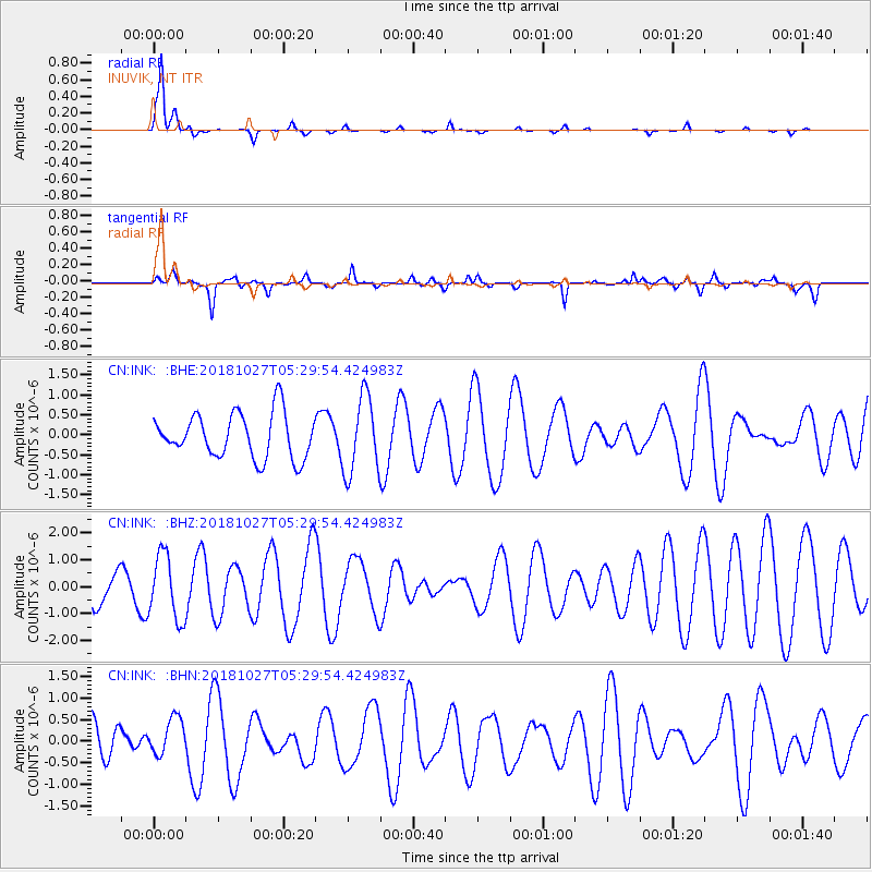
Signal To Noise
| Channel | StoN | STA | LTA |
| CN:INK: :BHZ:20181027T05:29:54.424983Z | 1.8498049 | 1.2032928E-6 | 6.5049716E-7 |
| CN:INK: :BHN:20181027T05:29:54.424983Z | 1.0143217 | 4.353192E-7 | 4.2917273E-7 |
| CN:INK: :BHE:20181027T05:29:54.424983Z | 1.7353376 | 9.64789E-7 | 5.5596615E-7 |
| Arrivals |
| Ps | |
| PpPs | |
| PsPs/PpSs | |


