You are here: Home > Network List > TS - TERRAscope (Southern California Seismic Network) Stations List
> Station BAR Barrett Dam, California, USA > Earthquake Result Viewer
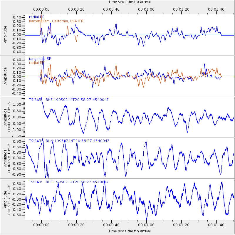
BAR Barrett Dam, California, USA - Earthquake Result Viewer
*The percent match for this event was below the threshold and hence no stack was calculated.
| Earthquake location: |
East Of Kuril Islands |
| Earthquake latitude/longitude: |
44.0/148.1 |
| Earthquake time(UTC): |
1995/02/14 (045) 20:47:41 GMT |
| Earthquake Depth: |
37 km |
| Earthquake Magnitude: |
5.9 MB, 5.6 MS, 5.9 UNKNOWN, 5.9 MW |
| Earthquake Catalog/Contributor: |
WHDF/NEIC |
|
| Network: |
TS TERRAscope (Southern California Seismic Network) |
| Station: |
BAR Barrett Dam, California, USA |
| Lat/Lon: |
32.68 N/116.67 W |
| Elevation: |
548 m |
|
| Distance: |
71.6 deg |
| Az: |
62.292 deg |
| Baz: |
310.737 deg |
| Ray Param: |
$rayparam |
*The percent match for this event was below the threshold and hence was not used in the summary stack. |
|
| Radial Match: |
64.68905 % |
| Radial Bump: |
400 |
| Transverse Match: |
56.217724 % |
| Transverse Bump: |
400 |
| SOD ConfigId: |
4480 |
| Insert Time: |
2010-02-26 13:59:39.614 +0000 |
| GWidth: |
2.5 |
| Max Bumps: |
400 |
| Tol: |
0.001 |
|
Signal To Noise
| Channel | StoN | STA | LTA |
| TS:BAR: :BHN:19950214T20:58:27.454004Z | 1.6782197 | 7.670607E-7 | 4.5706813E-7 |
| TS:BAR: :BHE:19950214T20:58:27.454004Z | 1.1497855 | 2.8594E-7 | 2.4868984E-7 |
| TS:BAR: :BHZ:19950214T20:58:27.454004Z | 0.95095927 | 5.6614334E-7 | 5.953392E-7 |
| Arrivals |
| Ps | |
| PpPs | |
| PsPs/PpSs | |


