You are here: Home > Network List > TA - USArray Transportable Network (new EarthScope stations) Stations List
> Station TOLK Toolik Lake Research Station, AK, USA > Earthquake Result Viewer
TOLK Toolik Lake Research Station, AK, USA - Earthquake Result Viewer

| Earthquake location: |
Southeast Of Loyalty Islands |
| Earthquake latitude/longitude: |
-22.5/173.1 |
| Earthquake time(UTC): |
2016/08/12 (225) 01:26:35 GMT |
| Earthquake Depth: |
10 km |
| Earthquake Magnitude: |
7.2 MWW, 7.6 MI |
| Earthquake Catalog/Contributor: |
NEIC PDE/NEIC COMCAT |
|
| Network: |
TA USArray Transportable Network (new EarthScope stations) |
| Station: |
TOLK Toolik Lake Research Station, AK, USA |
| Lat/Lon: |
68.64 N/149.57 W |
| Elevation: |
760 m |
|
| Distance: |
94.8 deg |
| Az: |
12.878 deg |
| Baz: |
214.239 deg |
| Ray Param: |
0.040938817 |
| Estimated Moho Depth: |
51.75 km |
| Estimated Crust Vp/Vs: |
1.63 |
| Assumed Crust Vp: |
6.316 km/s |
| Estimated Crust Vs: |
3.863 km/s |
| Estimated Crust Poisson's Ratio: |
0.20 |
|
| Radial Match: |
89.42432 % |
| Radial Bump: |
400 |
| Transverse Match: |
86.9824 % |
| Transverse Bump: |
400 |
| SOD ConfigId: |
1634031 |
| Insert Time: |
2016-08-26 01:29:07.500 +0000 |
| GWidth: |
2.5 |
| Max Bumps: |
400 |
| Tol: |
0.001 |
|
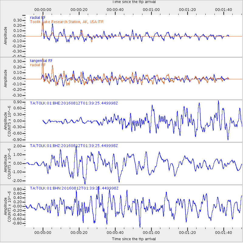
Signal To Noise
| Channel | StoN | STA | LTA |
| TA:TOLK:01:BHZ:20160812T01:39:25.449998Z | 5.637922 | 4.5041904E-7 | 7.989097E-8 |
| TA:TOLK:01:BHN:20160812T01:39:25.449998Z | 2.2272801 | 1.3799539E-7 | 6.195691E-8 |
| TA:TOLK:01:BHE:20160812T01:39:25.449998Z | 1.6450211 | 1.0076875E-7 | 6.125681E-8 |
| Arrivals |
| Ps | 5.3 SECOND |
| PpPs | 21 SECOND |
| PsPs/PpSs | 26 SECOND |


