You are here: Home > Network List > US - United States National Seismic Network Stations List
> Station AHID Auburn Hatchery, Idaho, USA > Earthquake Result Viewer
AHID Auburn Hatchery, Idaho, USA - Earthquake Result Viewer

| Earthquake location: |
Southeast Of Loyalty Islands |
| Earthquake latitude/longitude: |
-22.5/173.1 |
| Earthquake time(UTC): |
2016/08/12 (225) 01:26:35 GMT |
| Earthquake Depth: |
10 km |
| Earthquake Magnitude: |
7.2 MWW, 7.6 MI |
| Earthquake Catalog/Contributor: |
NEIC PDE/NEIC COMCAT |
|
| Network: |
US United States National Seismic Network |
| Station: |
AHID Auburn Hatchery, Idaho, USA |
| Lat/Lon: |
42.77 N/111.10 W |
| Elevation: |
1960 m |
|
| Distance: |
95.2 deg |
| Az: |
45.79 deg |
| Baz: |
244.181 deg |
| Ray Param: |
0.040852666 |
| Estimated Moho Depth: |
17.75 km |
| Estimated Crust Vp/Vs: |
1.60 |
| Assumed Crust Vp: |
6.207 km/s |
| Estimated Crust Vs: |
3.879 km/s |
| Estimated Crust Poisson's Ratio: |
0.18 |
|
| Radial Match: |
91.11253 % |
| Radial Bump: |
400 |
| Transverse Match: |
87.878494 % |
| Transverse Bump: |
341 |
| SOD ConfigId: |
1634031 |
| Insert Time: |
2016-08-26 01:29:09.738 +0000 |
| GWidth: |
2.5 |
| Max Bumps: |
400 |
| Tol: |
0.001 |
|
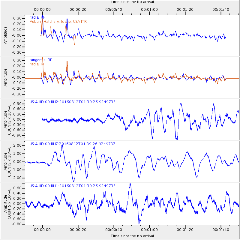
Signal To Noise
| Channel | StoN | STA | LTA |
| US:AHID:00:BHZ:20160812T01:39:26.924973Z | 5.014471 | 2.0626477E-7 | 4.1133905E-8 |
| US:AHID:00:BH1:20160812T01:39:26.924973Z | 2.1311657 | 9.7229716E-8 | 4.5622787E-8 |
| US:AHID:00:BH2:20160812T01:39:26.924973Z | 1.3432087 | 7.4283705E-8 | 5.5303172E-8 |
| Arrivals |
| Ps | 1.8 SECOND |
| PpPs | 7.3 SECOND |
| PsPs/PpSs | 9.0 SECOND |


