You are here: Home > Network List > TA - USArray Transportable Network (new EarthScope stations) Stations List
> Station X21A Alamocita Creek, Datil, NM, USA > Earthquake Result Viewer
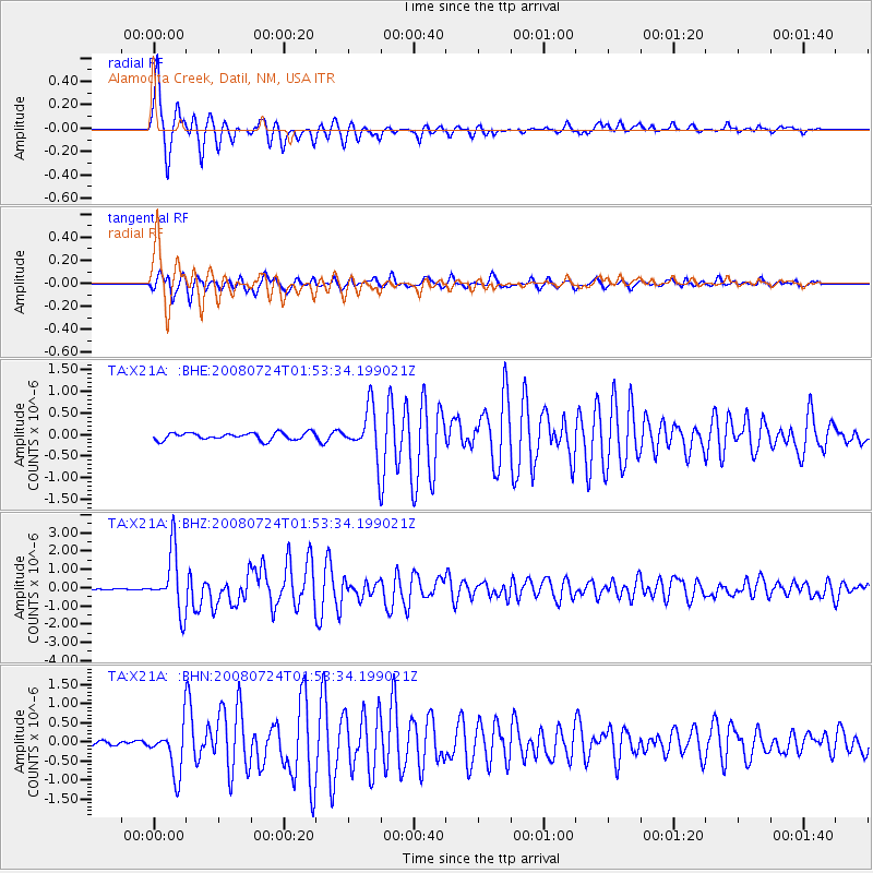
X21A Alamocita Creek, Datil, NM, USA - Earthquake Result Viewer
| Earthquake location: |
Kuril Islands |
| Earthquake latitude/longitude: |
51.0/157.6 |
| Earthquake time(UTC): |
2008/07/24 (206) 01:43:16 GMT |
| Earthquake Depth: |
27 km |
| Earthquake Magnitude: |
6.0 MB, 6.0 MS, 6.2 MW, 6.2 MW |
| Earthquake Catalog/Contributor: |
WHDF/NEIC |
|
| Network: |
TA USArray Transportable Network (new EarthScope stations) |
| Station: |
X21A Alamocita Creek, Datil, NM, USA |
| Lat/Lon: |
34.45 N/107.79 W |
| Elevation: |
2141 m |
|
| Distance: |
66.8 deg |
| Az: |
63.667 deg |
| Baz: |
316.707 deg |
| Ray Param: |
0.05734034 |
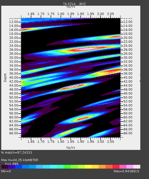
| Estimated Moho Depth: |
44.25 km |
| Estimated Crust Vp/Vs: |
1.87 |
| Assumed Crust Vp: |
6.502 km/s |
| Estimated Crust Vs: |
3.486 km/s |
| Estimated Crust Poisson's Ratio: |
0.30 |
|
| Radial Match: |
97.24333 % |
| Radial Bump: |
305 |
| Transverse Match: |
91.23585 % |
| Transverse Bump: |
383 |
| SOD ConfigId: |
2504 |
| Insert Time: |
2010-03-06 17:14:51.625 +0000 |
| GWidth: |
2.5 |
| Max Bumps: |
400 |
| Tol: |
0.001 |
|
Signal To Noise
| Channel | StoN | STA | LTA |
| TA:X21A: :BHZ:20080724T01:53:34.199021Z | 20.328606 | 1.6106125E-6 | 7.9228876E-8 |
| TA:X21A: :BHN:20080724T01:53:34.199021Z | 9.055888 | 6.159549E-7 | 6.801706E-8 |
| TA:X21A: :BHE:20080724T01:53:34.199021Z | 6.8422666 | 5.6905736E-7 | 8.316796E-8 |
| Arrivals |
| Ps | 6.1 SECOND |
| PpPs | 19 SECOND |
| PsPs/PpSs | 25 SECOND |


