You are here: Home > Network List > TA - USArray Transportable Network (new EarthScope stations) Stations List
> Station X21A Alamocita Creek, Datil, NM, USA > Earthquake Result Viewer
X21A Alamocita Creek, Datil, NM, USA - Earthquake Result Viewer
| Earthquake location: |
Rat Islands, Aleutian Islands |
| Earthquake latitude/longitude: |
51.3/179.0 |
| Earthquake time(UTC): |
2008/07/25 (207) 00:29:22 GMT |
| Earthquake Depth: |
21 km |
| Earthquake Magnitude: |
5.7 MB, 5.5 MS, 5.9 MW, 5.9 MW |
| Earthquake Catalog/Contributor: |
WHDF/NEIC |
|
| Network: |
TA USArray Transportable Network (new EarthScope stations) |
| Station: |
X21A Alamocita Creek, Datil, NM, USA |
| Lat/Lon: |
34.45 N/107.79 W |
| Elevation: |
2141 m |
|
| Distance: |
54.0 deg |
| Az: |
78.006 deg |
| Baz: |
311.978 deg |
| Ray Param: |
0.06569956 |
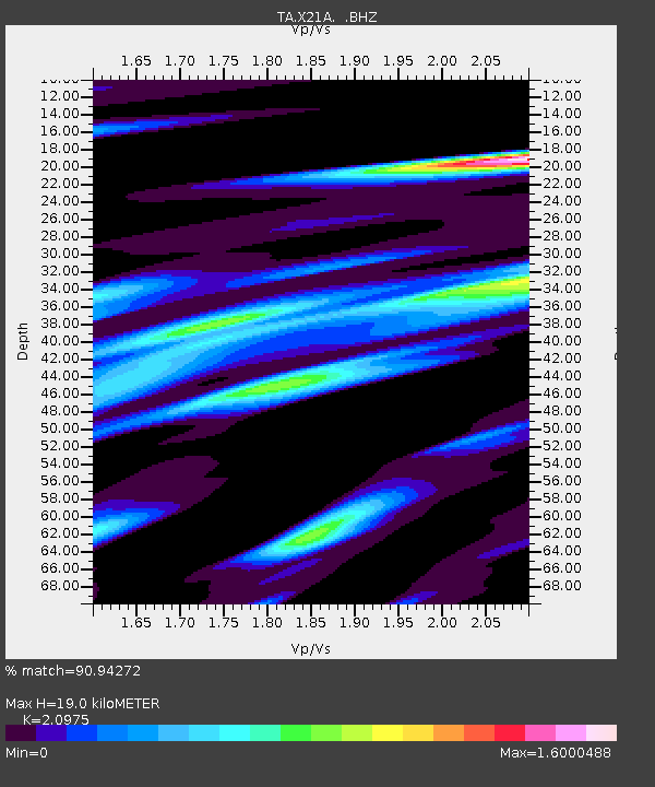
| Estimated Moho Depth: |
19.0 km |
| Estimated Crust Vp/Vs: |
2.10 |
| Assumed Crust Vp: |
6.502 km/s |
| Estimated Crust Vs: |
3.1 km/s |
| Estimated Crust Poisson's Ratio: |
0.35 |
|
| Radial Match: |
90.94272 % |
| Radial Bump: |
400 |
| Transverse Match: |
83.25776 % |
| Transverse Bump: |
400 |
| SOD ConfigId: |
2504 |
| Insert Time: |
2010-03-06 17:14:53.355 +0000 |
| GWidth: |
2.5 |
| Max Bumps: |
400 |
| Tol: |
0.001 |
|

Signal To Noise
| Channel | StoN | STA | LTA |
| TA:X21A: :BHZ:20080725T00:38:14.475005Z | 11.817296 | 6.614757E-7 | 5.597522E-8 |
| TA:X21A: :BHN:20080725T00:38:14.475005Z | 3.8858833 | 3.7226835E-7 | 9.580018E-8 |
| TA:X21A: :BHE:20080725T00:38:14.475005Z | 4.1680536 | 3.205501E-7 | 7.6906424E-8 |
| Arrivals |
| Ps | 3.4 SECOND |
| PpPs | 8.6 SECOND |
| PsPs/PpSs | 12 SECOND |


