You are here: Home > Network List > TA - USArray Transportable Network (new EarthScope stations) Stations List
> Station X21A Alamocita Creek, Datil, NM, USA > Earthquake Result Viewer
X21A Alamocita Creek, Datil, NM, USA - Earthquake Result Viewer
| Earthquake location: |
Andreanof Islands, Aleutian Is. |
| Earthquake latitude/longitude: |
51.6/-174.4 |
| Earthquake time(UTC): |
2008/11/02 (307) 13:48:42 GMT |
| Earthquake Depth: |
36 km |
| Earthquake Magnitude: |
5.7 MB, 5.8 MS, 6.1 MW, 6.1 MW |
| Earthquake Catalog/Contributor: |
WHDF/NEIC |
|
| Network: |
TA USArray Transportable Network (new EarthScope stations) |
| Station: |
X21A Alamocita Creek, Datil, NM, USA |
| Lat/Lon: |
34.45 N/107.79 W |
| Elevation: |
2141 m |
|
| Distance: |
49.8 deg |
| Az: |
82.863 deg |
| Baz: |
311.441 deg |
| Ray Param: |
0.068372004 |
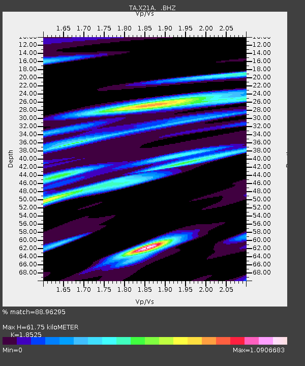
| Estimated Moho Depth: |
61.75 km |
| Estimated Crust Vp/Vs: |
1.85 |
| Assumed Crust Vp: |
6.502 km/s |
| Estimated Crust Vs: |
3.51 km/s |
| Estimated Crust Poisson's Ratio: |
0.29 |
|
| Radial Match: |
88.96295 % |
| Radial Bump: |
363 |
| Transverse Match: |
67.85963 % |
| Transverse Bump: |
394 |
| SOD ConfigId: |
2658 |
| Insert Time: |
2010-03-06 17:14:58.946 +0000 |
| GWidth: |
2.5 |
| Max Bumps: |
400 |
| Tol: |
0.001 |
|
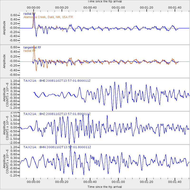
Signal To Noise
| Channel | StoN | STA | LTA |
| TA:X21A: :BHZ:20081102T13:57:01.800011Z | 4.128462 | 4.4210464E-7 | 1.0708701E-7 |
| TA:X21A: :BHN:20081102T13:57:01.800011Z | 1.4135318 | 2.9295936E-7 | 2.0725346E-7 |
| TA:X21A: :BHE:20081102T13:57:01.800011Z | 2.414388 | 3.202316E-7 | 1.3263468E-7 |
| Arrivals |
| Ps | 8.6 SECOND |
| PpPs | 26 SECOND |
| PsPs/PpSs | 34 SECOND |


